GIS Technicians in forestry specialize in managing and analyzing spatial data through geographic information systems to map forests, track wildlife habitats, and support sustainable resource management. Remote Sensing Analysts utilize satellite or aerial imagery to monitor forest health, detect changes over time, and assess impacts of environmental factors like fires or pests. The combination of GIS technical skills and remote sensing expertise enhances precision in forestry planning and conservation efforts.
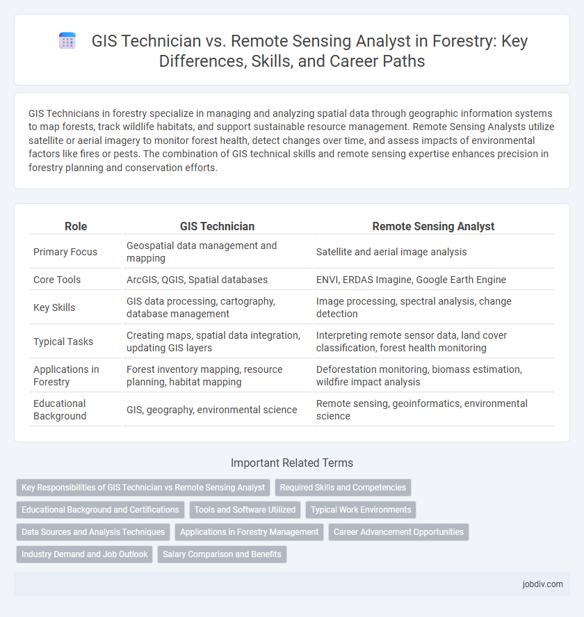
Table of Comparison
| Role | GIS Technician | Remote Sensing Analyst |
|---|---|---|
| Primary Focus | Geospatial data management and mapping | Satellite and aerial image analysis |
| Core Tools | ArcGIS, QGIS, Spatial databases | ENVI, ERDAS Imagine, Google Earth Engine |
| Key Skills | GIS data processing, cartography, database management | Image processing, spectral analysis, change detection |
| Typical Tasks | Creating maps, spatial data integration, updating GIS layers | Interpreting remote sensor data, land cover classification, forest health monitoring |
| Applications in Forestry | Forest inventory mapping, resource planning, habitat mapping | Deforestation monitoring, biomass estimation, wildfire impact analysis |
| Educational Background | GIS, geography, environmental science | Remote sensing, geoinformatics, environmental science |
Key Responsibilities of GIS Technician vs Remote Sensing Analyst
GIS Technicians primarily manage spatial data, create and update maps, and ensure data accuracy within Geographic Information Systems, supporting forestry planning and resource management. Remote Sensing Analysts specialize in processing satellite and aerial imagery to monitor forest health, detect changes, and analyze environmental impacts using advanced image analysis techniques. Both roles are critical in forestry, with GIS Technicians focusing on data handling and map production, while Remote Sensing Analysts concentrate on interpreting remote sensor data to inform decision-making.
Required Skills and Competencies
GIS Technicians require proficiency in spatial data management, cartographic principles, and GIS software such as ArcGIS and QGIS, emphasizing accuracy in data entry and map production. Remote Sensing Analysts must excel in image processing, spectral analysis, and interpreting satellite or aerial data using tools like ENVI or ERDAS Imagine, with strong skills in programming languages such as Python or R for data modeling. Both roles demand expertise in geographic information systems, but Remote Sensing Analysts focus more on advanced analytical techniques and sensor technology understanding for effective forestry monitoring.
Educational Background and Certifications
GIS Technicians in forestry typically hold associate or bachelor's degrees in geography, environmental science, or forestry, often complemented by certifications such as the GIS Professional (GISP) or Esri Technical Certification. Remote Sensing Analysts usually require a stronger emphasis on advanced degrees in remote sensing, geospatial science, or earth sciences, with specialized certifications like the Certified Remote Sensing Technologist (CRST) or training in software such as ENVI and ERDAS IMAGINE. Both roles benefit from hands-on experience with geospatial data, but Remote Sensing Analysts generally have more expertise in satellite and aerial imagery interpretation critical for sustainable forest management.
Tools and Software Utilized
GIS Technicians primarily use software like ArcGIS, QGIS, and MapInfo to create, analyze, and manage spatial data for forestry applications, enabling detailed mapping and land-use planning. Remote Sensing Analysts rely on tools such as ENVI, ERDAS IMAGINE, and Google Earth Engine to interpret satellite and aerial imagery for vegetation health assessment, forest cover monitoring, and change detection. Both roles integrate GPS technology and spatial databases, but Remote Sensing Analysts focus more on image processing algorithms and spectral data analysis to support sustainable forest management.
Typical Work Environments
GIS Technicians typically work in forestry offices, environmental consulting firms, and government agencies where they manage spatial data and create maps using GIS software. Remote Sensing Analysts often operate in research institutions, forestry management companies, and satellite data centers, analyzing aerial or satellite imagery to monitor forest health and land cover changes. Both roles frequently collaborate in fieldwork settings and require access to advanced computer labs equipped with specialized software for spatial analysis.
Data Sources and Analysis Techniques
GIS Technicians primarily utilize spatial data from satellite imagery, aerial photography, and field surveys, applying GIS software like ArcGIS to create, manage, and analyze geospatial databases for forestry applications. Remote Sensing Analysts focus on processing and interpreting multispectral and hyperspectral imagery from satellites and drones using advanced image analysis techniques such as classification, spectral indices, and change detection to monitor forest health and biomass. Both roles collaborate closely, but GIS Technicians emphasize geospatial data integration and map production, while Remote Sensing Analysts concentrate on extracting detailed information from remote sensor data for forest management decisions.
Applications in Forestry Management
GIS Technicians in forestry specialize in spatial data management, creating detailed maps and analyzing terrain features crucial for forest inventory and harvest planning. Remote Sensing Analysts interpret satellite and aerial imagery to monitor forest health, detect deforestation, and assess wildfire damage with precision. Both roles employ advanced geospatial technologies, enhancing sustainable forestry management through accurate environmental assessments and resource monitoring.
Career Advancement Opportunities
GIS Technicians typically advance by gaining expertise in spatial data management and software like ArcGIS, leading to roles such as GIS Analyst or Project Coordinator. Remote Sensing Analysts progress by mastering sensor technologies and image processing tools like ENVI or ERDAS, which opens opportunities in environmental consultancy or specialized research positions. Both career paths offer growth into leadership roles within forestry management, but Remote Sensing Analysts often have a higher demand in advanced ecological monitoring and climate impact studies.
Industry Demand and Job Outlook
GIS Technicians and Remote Sensing Analysts are both in high demand within the forestry industry due to increasing reliance on geospatial technologies for forest management and conservation. GIS Technicians primarily focus on data collection, map creation, and spatial database management, whereas Remote Sensing Analysts specialize in interpreting satellite and aerial imagery to monitor forest health and disturbances. The job outlook for both roles is strong, with Remote Sensing Analysts seeing higher growth potential as advancements in drone technology and AI-driven image processing expand remote sensing applications in forestry.
Salary Comparison and Benefits
GIS Technicians in forestry earn an average annual salary of $45,000 to $60,000, focusing on spatial data management and map production, while Remote Sensing Analysts typically command higher salaries ranging from $60,000 to $80,000 due to expertise in analyzing satellite and aerial imagery for forest monitoring. Benefits for GIS Technicians often include standard healthcare and retirement plans, whereas Remote Sensing Analysts frequently receive additional perks such as advanced training opportunities and project leadership roles that enhance career growth. Both positions are critical in forest resource management, but Remote Sensing Analysts' specialized skills usually translate into greater financial compensation and professional development advantages.
GIS Technician vs Remote Sensing Analyst Infographic