A geophysicist studies the physical properties and processes of the Earth, such as seismic activity, magnetic fields, and gravitational forces, using techniques like seismology and magnetometry. A geodesist specializes in measuring and understanding Earth's geometric shape, orientation, and gravity field, often employing satellite data, GPS, and geodetic surveys to model Earth's surface accurately. While both fields overlap in analyzing Earth's characteristics, geophysics emphasizes internal processes, whereas geodesy focuses on precise spatial measurements and Earth's geometry.
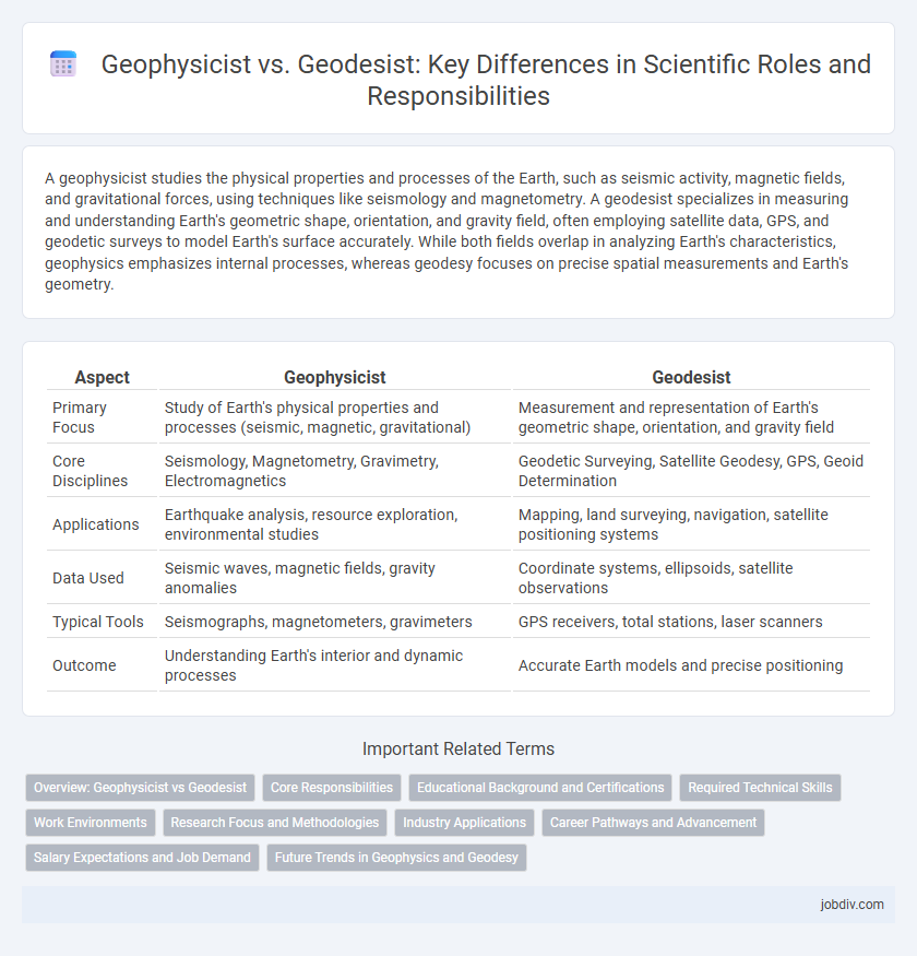
Table of Comparison
| Aspect | Geophysicist | Geodesist |
|---|---|---|
| Primary Focus | Study of Earth's physical properties and processes (seismic, magnetic, gravitational) | Measurement and representation of Earth's geometric shape, orientation, and gravity field |
| Core Disciplines | Seismology, Magnetometry, Gravimetry, Electromagnetics | Geodetic Surveying, Satellite Geodesy, GPS, Geoid Determination |
| Applications | Earthquake analysis, resource exploration, environmental studies | Mapping, land surveying, navigation, satellite positioning systems |
| Data Used | Seismic waves, magnetic fields, gravity anomalies | Coordinate systems, ellipsoids, satellite observations |
| Typical Tools | Seismographs, magnetometers, gravimeters | GPS receivers, total stations, laser scanners |
| Outcome | Understanding Earth's interior and dynamic processes | Accurate Earth models and precise positioning |
Overview: Geophysicist vs Geodesist
Geophysicists study the physical properties of the Earth using seismic, magnetic, electrical, and gravitational data to understand processes like earthquakes, volcanoes, and plate tectonics. Geodesists specialize in measuring Earth's shape, orientation, and gravitational field through satellite geodesy, GPS, and terrestrial surveying to monitor tectonic movements, sea-level changes, and land deformation. Both fields contribute to Earth sciences, but geophysicists focus on subsurface phenomena while geodesists emphasize precise spatial measurements and Earth's geometry.
Core Responsibilities
Geophysicists analyze Earth's physical properties using seismic, magnetic, and gravitational data to study phenomena such as earthquakes, volcanic activity, and Earth's internal structure. Geodesists specialize in measuring and monitoring Earth's geometric shape, gravitational field, and rotation through satellite geodesy, GPS, and leveling techniques to support precise mapping and navigation. Core responsibilities of geophysicists involve interpreting subsurface geological formations, while geodesists focus on maintaining accurate geospatial reference systems and crustal deformation monitoring.
Educational Background and Certifications
Geophysicists typically hold degrees in geophysics, physics, or earth sciences, often requiring advanced education such as a master's or doctoral degree to engage in research or specialized roles. Geodesists usually earn degrees in geodesy, geomatics, or surveying engineering, with certifications like the Professional Land Surveyor (PLS) license enhancing their qualifications for precise earth measurement and mapping. Both professions benefit from continuous certification options, including the Certified Geophysicist and Geospatial Information Systems Professional (GISP) credentials, ensuring expertise in evolving technologies.
Required Technical Skills
Geophysicists require expertise in seismic data analysis, geophysical modeling, and interpretation of subsurface physical properties using tools like magnetometers and gravimeters. Geodesists must have advanced skills in geodetic surveying, GPS technology, and precise measurement of Earth's shape, gravitational field, and spatial reference systems. Both fields demand proficiency in data processing software, but geophysicists prioritize signal processing, while geodesists emphasize spatial analysis and coordinate system management.
Work Environments
Geophysicists primarily conduct research in academic institutions, government agencies, and private sector laboratories, using advanced technology to study Earth's physical properties and processes. Geodesists frequently work for national mapping agencies, surveying firms, or space organizations, focusing on measuring Earth's shape, gravity field, and geospatial data collection. Both professionals often collaborate in fieldwork environments, utilizing specialized instruments such as gravimeters, GPS, and remote sensing equipment.
Research Focus and Methodologies
Geophysicists primarily research Earth's physical properties through methods such as seismic imaging, gravity measurements, and electromagnetic surveys to understand processes like tectonic activity and Earth's internal structure. Geodesists focus on measuring and monitoring Earth's geometric shape, orientation in space, and gravitational field using satellite geodesy, GPS, and leveling techniques to support precise mapping and navigation. While geophysicists analyze subsurface phenomena, geodesists optimize spatial reference systems crucial for geospatial data accuracy and land surveying.
Industry Applications
Geophysicists analyze Earth's physical properties using seismic, magnetic, and gravitational data to explore natural resources such as oil, gas, and minerals, playing a critical role in the energy and mining industries. Geodesists specialize in measuring Earth's geometric shape, orientation, and gravitational field to support precision mapping, land surveying, and satellite navigation systems used in construction, transportation, and telecommunications sectors. Both disciplines integrate advanced technologies like GPS, remote sensing, and geospatial data analytics to optimize resource management and infrastructure development.
Career Pathways and Advancement
Geophysicists often pursue advanced degrees in physics or earth sciences with career pathways spanning energy exploration, environmental consulting, and seismic research, while geodesists specialize in measuring Earth's geometric shape, gravity field, and rotation, advancing through roles in surveying, satellite geodesy, and mapping technologies. Both professions require strong analytical skills and proficiency in geospatial technologies, but career advancement for geodesists frequently involves expertise in GPS, remote sensing, and GIS software, whereas geophysicists often focus on data interpretation and modeling techniques in geophysical surveys. Professional certifications like the American Geophysical Union membership or the National Society of Professional Surveyors credentials can enhance career opportunities and leadership positions within their respective fields.
Salary Expectations and Job Demand
Geophysicists typically earn an average salary ranging from $65,000 to $110,000 annually, driven by demand in oil, gas, and environmental sectors, with job growth projected at about 7% over the next decade. Geodesists, specializing in Earth's geometric shape and gravitational field measurements, have a median salary near $70,000, supported by steady demand in mapping, navigation, and surveying industries with a slightly slower growth rate of approximately 4%. Salary expectations for geophysicists are generally higher due to their broader application in energy exploration and research, while geodesists benefit from consistent employment opportunities tied to infrastructure development and geospatial technology advancements.
Future Trends in Geophysics and Geodesy
Future trends in geophysics emphasize the integration of advanced remote sensing technologies and machine learning algorithms to enhance subsurface imaging and earthquake prediction accuracy. Geodesy is progressing towards ultra-precise satellite navigation systems and quantum gravimetry, enabling real-time monitoring of Earth's shape, gravity field, and tectonic movements. The convergence of geophysical data analytics and geodetic measurements will drive more accurate climate modeling and natural hazard assessment.
Geophysicist vs Geodesist Infographic