Flood risk assessors evaluate the likelihood and potential impact of flooding events by analyzing rainfall patterns, topography, and drainage systems to protect communities and infrastructure. Drought risk assessors focus on long-term water scarcity, examining soil moisture, precipitation deficits, and water consumption trends to develop strategies for sustainable water management. Both roles are essential for adaptive planning and resilience in water resource management under changing climate conditions.
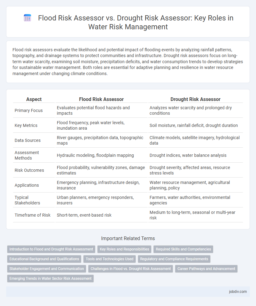
Table of Comparison
| Aspect | Flood Risk Assessor | Drought Risk Assessor |
|---|---|---|
| Primary Focus | Evaluates potential flood hazards and impacts | Analyzes water scarcity and prolonged dry conditions |
| Key Metrics | Flood frequency, peak water levels, inundation area | Soil moisture, rainfall deficit, drought duration |
| Data Sources | River gauges, precipitation data, topographic maps | Climate models, satellite imagery, hydrological data |
| Assessment Methods | Hydraulic modeling, floodplain mapping | Drought indices, water balance analysis |
| Risk Outcomes | Flood probability, vulnerability zones, damage estimates | Drought severity, affected areas, resource stress levels |
| Applications | Emergency planning, infrastructure design, insurance | Water resource management, agricultural planning, policy |
| Typical Stakeholders | Urban planners, emergency responders, insurers | Farmers, water authorities, environmental agencies |
| Timeframe of Risk | Short-term, event-based risk | Medium to long-term, seasonal or multi-year risk |
Introduction to Flood and Drought Risk Assessment
Flood risk assessment evaluates potential hazards from excessive rainfall, river overflow, or storm surges by analyzing historical data, topography, and infrastructure vulnerability. Drought risk assessment focuses on the likelihood and impact of prolonged water shortages by monitoring precipitation patterns, soil moisture levels, and water demand trends. Both assessments aim to inform water resource management and disaster preparedness but address distinctly different environmental threats.
Key Roles and Responsibilities
Flood Risk Assessors specialize in evaluating areas prone to flooding by analyzing hydrological data, topography, and climate patterns to develop mitigation strategies and emergency response plans. Drought Risk Assessors focus on monitoring water scarcity through assessing rainfall trends, soil moisture levels, and groundwater availability to forecast drought conditions and recommend water conservation measures. Both roles require expertise in environmental data analysis and risk management to protect communities and infrastructure from water-related disasters.
Required Skills and Competencies
Flood Risk Assessors require strong hydrological modeling skills, proficiency in GIS mapping, and expertise in interpreting precipitation and river flow data to evaluate flood scenarios accurately. Drought Risk Assessors need comprehensive knowledge of soil moisture analysis, climate variability, and water resource management, along with competencies in remote sensing and drought early warning systems. Both roles demand critical analytical abilities and familiarity with risk assessment frameworks specific to water-related hazards.
Educational Background and Qualifications
Flood Risk Assessors typically have educational backgrounds in hydrology, civil engineering, or environmental science, with qualifications including certifications in flood modeling and risk management. Drought Risk Assessors often hold degrees in climatology, environmental science, or agricultural studies, emphasizing drought monitoring techniques and water resource management certifications. Both roles require analytical skills and specialized training in their respective risk assessment methodologies to effectively evaluate and mitigate water-related hazards.
Tools and Technologies Used
Flood risk assessors utilize hydrological models, Geographic Information Systems (GIS), and remote sensing technologies such as satellite imagery and LiDAR to analyze floodplain dynamics, water flow, and precipitation patterns. Drought risk assessors employ soil moisture sensors, climate models, evapotranspiration data, and drought indices like the Standardized Precipitation Evapotranspiration Index (SPEI) to evaluate water scarcity and vegetation stress. Both professions leverage advanced data analytics and machine learning algorithms to predict risk scenarios and support water resource management decisions.
Regulatory and Compliance Requirements
Flood Risk Assessors must comply with rigorous regulatory frameworks such as the National Flood Insurance Program (NFIP) and local zoning laws that mandate floodplain mapping and mitigation strategies. Drought Risk Assessors follow specific water management regulations including the Sustainable Groundwater Management Act (SGMA) and region-specific drought contingency plans to ensure sustainable water usage. Both roles require adherence to environmental protection standards and timely reporting to regulatory bodies to minimize risk and ensure community resilience.
Stakeholder Engagement and Communication
Flood Risk Assessors engage with diverse stakeholders including local authorities, emergency responders, and community members to communicate hazard maps, evacuation plans, and mitigation strategies effectively. Drought Risk Assessors collaborate closely with agricultural sectors, water resource managers, and policymakers to share data on water scarcity, forecast drought severity, and promote efficient water use practices. Both roles require tailored communication methods to raise awareness and support informed decision-making amid varying water-related risks.
Challenges in Flood vs. Drought Risk Assessment
Flood Risk Assessors face challenges such as unpredictability of rainfall patterns, rapid water level changes, and urban infrastructure vulnerability, which complicate accurate flood modeling and forecasting. Drought Risk Assessors encounter difficulties due to prolonged periods of low precipitation, groundwater depletion, and delayed impacts on water supply, which hamper timely detection and mitigation efforts. Both assessments require integrating climate data, hydrological models, and socio-economic factors to effectively manage water resources and reduce disaster impacts.
Career Pathways and Advancement
Flood Risk Assessors analyze hydrological data and terrain to predict flood scenarios, often advancing into roles like Environmental Consultant or Water Resource Manager by gaining expertise in GIS and climate modeling. Drought Risk Assessors specialize in monitoring precipitation patterns and soil moisture, progressing toward careers in Agricultural Planning or Climate Resilience Strategy through skills in remote sensing and drought mitigation techniques. Both career paths offer opportunities in policy development and emergency management, with growth driven by increasing global water security challenges.
Emerging Trends in Water Sector Risk Assessment
Flood Risk Assessors focus on analyzing precipitation patterns, river flow data, and urban drainage systems to predict and mitigate the impact of rising water levels, while Drought Risk Assessors evaluate soil moisture, reservoir capacity, and climate variability to manage water scarcity challenges. Emerging trends in the water sector emphasize integrating remote sensing technology, AI-driven predictive models, and real-time monitoring to enhance accuracy in risk assessment. Collaboration between flood and drought assessment methodologies is increasing to develop more comprehensive water management strategies under changing climate conditions.
Flood Risk Assessor vs Drought Risk Assessor Infographic