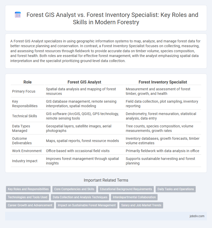
A Forest GIS Analyst specializes in using geographic information systems to map, analyze, and manage forest data for better resource planning and conservation. In contrast, a Forest Inventory Specialist focuses on collecting, measuring, and assessing forest resources through fieldwork to provide accurate data on timber volume, species composition, and forest health. Both roles are essential for effective forest management, with the analyst emphasizing spatial data interpretation and the specialist prioritizing ground-level data collection.
Table of Comparison
| Role | Forest GIS Analyst | Forest Inventory Specialist |
|---|---|---|
| Primary Focus | Spatial data analysis and mapping of forest resources | Measurement and assessment of forest timber, growth, and health |
| Key Responsibilities | GIS database management, remote sensing interpretation, spatial modeling | Field data collection, plot sampling, inventory reporting |
| Technical Skills | GIS software (ArcGIS, QGIS), GPS technology, remote sensing tools | Dendrometry, forest mensuration, statistical analysis, data entry |
| Data Types Managed | Geospatial layers, satellite images, aerial photographs | Tree counts, species composition, volume measurements, growth rates |
| Outcome Deliverables | Maps, spatial reports, forest resource models | Inventory databases, growth forecasts, timber volume estimates |
| Work Environment | Office-based with occasional field visits | Primarily fieldwork with data analysis in office |
| Industry Impact | Improves forest management through spatial insights | Supports sustainable harvesting and forest planning |
Key Roles and Responsibilities
A Forest GIS Analyst specializes in mapping and spatial data analysis using geographic information systems to support forest management, wildfire monitoring, and conservation planning. A Forest Inventory Specialist focuses on collecting, analyzing, and interpreting forest inventory data such as tree species, density, growth rates, and health to inform sustainable forest management and timber harvesting decisions. Both roles are critical for effective forest resource assessment but differ in their primary tools and data management techniques.
Core Competencies and Skills
A Forest GIS Analyst excels in spatial data management, remote sensing, and geospatial analysis using software like ArcGIS and QGIS to create detailed forest maps and monitor ecological changes. In contrast, a Forest Inventory Specialist focuses on field data collection, sampling methodologies, and statistical analysis to assess forest composition, volume, and health for sustainable management practices. Both roles demand strong analytical skills and proficiency in forest ecology, but GIS Analysts prioritize geospatial technology while Inventory Specialists emphasize empirical data accuracy and forest measurement techniques.
Educational Background Requirements
A Forest GIS Analyst typically requires a degree in Geographic Information Systems, Forestry, Environmental Science, or a related field with strong skills in geospatial analysis, remote sensing, and data management. A Forest Inventory Specialist usually holds a degree in Forestry, Natural Resources, or Wildlife Management, emphasizing field data collection, forest measurement techniques, and statistical analysis. Both roles benefit from coursework in forest ecology and statistics, but GIS Analysts prioritize technical proficiency in spatial software while Inventory Specialists focus on practical forest assessment methods.
Daily Tasks and Operations
Forest GIS Analysts primarily manage spatial data, create detailed maps, and use geographic information systems to analyze forest resources for planning and management. Forest Inventory Specialists conduct field surveys to collect data on tree species, health, and volume, then process and interpret this information to assess forest conditions and growth. Both roles collaborate to support sustainable forest management, with GIS Analysts focusing on data visualization and spatial analysis, while Inventory Specialists emphasize accurate data collection and ground-truth verification.
Technologies and Tools Used
Forest GIS Analysts utilize advanced Geographic Information Systems (GIS) software such as ArcGIS, QGIS, and remote sensing tools to analyze spatial data and generate detailed forest maps for resource management. Forest Inventory Specialists employ tools including GPS devices, laser rangefinders, and specialized software like Forest Metrix or BIGS to collect and analyze tree measurements, species data, and stand structure for accurate forest assessments. Both roles integrate drone technology and satellite imagery, but GIS Analysts emphasize spatial data modeling while Inventory Specialists focus on field data accuracy and inventory systems.
Data Collection and Analysis Techniques
Forest GIS Analysts utilize advanced geospatial technologies such as remote sensing, GPS mapping, and spatial data modeling to collect, analyze, and visualize forest data, enabling precise habitat mapping and resource management. Forest Inventory Specialists primarily focus on ground-based data collection techniques, including sample plot measurements, tree marking, and dendrometry, combined with statistical analysis to assess timber volume, species composition, and forest health. Both roles integrate data analysis, but GIS Analysts emphasize spatial data integration and remote sensing, while Inventory Specialists concentrate on field data accuracy and quantitative forest metrics.
Interdepartmental Collaboration
Forest GIS Analysts use spatial data and mapping technologies to support forest planning and resource management, enabling precise visualization of forest conditions. Forest Inventory Specialists collect and analyze field data on tree species, density, and health to provide accurate forest composition assessments. Effective interdepartmental collaboration between these roles enhances decision-making by integrating spatial analysis with comprehensive forest inventory data.
Career Growth and Advancement
Forest GIS Analysts leverage geospatial technologies to map and analyze forest landscapes, cultivating skills in remote sensing and spatial data management that open pathways to advanced roles in environmental consulting and resource management. Forest Inventory Specialists concentrate on data collection and field measurement of forest resources, providing critical insights for sustainable management practices and advancing toward leadership positions in forest planning and silviculture. Both careers offer strong growth potential, with GIS expertise driving innovation in forest monitoring, while inventory specialization supports vital decision-making in conservation and economic assessments.
Impact on Sustainable Forest Management
Forest GIS Analysts leverage spatial data technologies to map and monitor forest ecosystems, enabling precise assessments of forest health, biodiversity, and carbon storage critical for sustainable forest management. Forest Inventory Specialists systematically collect and analyze quantitative data on tree species, density, and growth, providing essential metrics to inform timber harvesting practices and conservation strategies. Integrating spatial analysis with inventory data enhances decision-making processes, promoting balanced resource use and long-term ecological sustainability.
Salary and Job Market Trends
Forest GIS Analysts command an average salary ranging from $55,000 to $75,000 annually, driven by expertise in spatial data analysis and remote sensing technologies within forestry management. Forest Inventory Specialists earn comparable median salaries between $50,000 and $70,000, with demand concentrated in timber valuation, resource assessment, and sustainable forest management sectors. Recent job market trends highlight a growing preference for GIS proficiency, boosting Forest GIS Analyst opportunities in government agencies and environmental consulting firms.
Forest GIS Analyst vs Forest Inventory Specialist Infographic