Forest GIS Analysts specialize in managing and analyzing spatial data to support forestry planning and resource management, using GIS software to create detailed maps and models of forest landscapes. Remote Sensing Specialists focus on acquiring and interpreting satellite or aerial imagery to monitor forest health, detect changes, and assess ecosystem conditions over time. Both roles contribute critical data insights, but GIS Analysts emphasize spatial data integration while Remote Sensing Specialists prioritize image processing and interpretation.
Table of Comparison
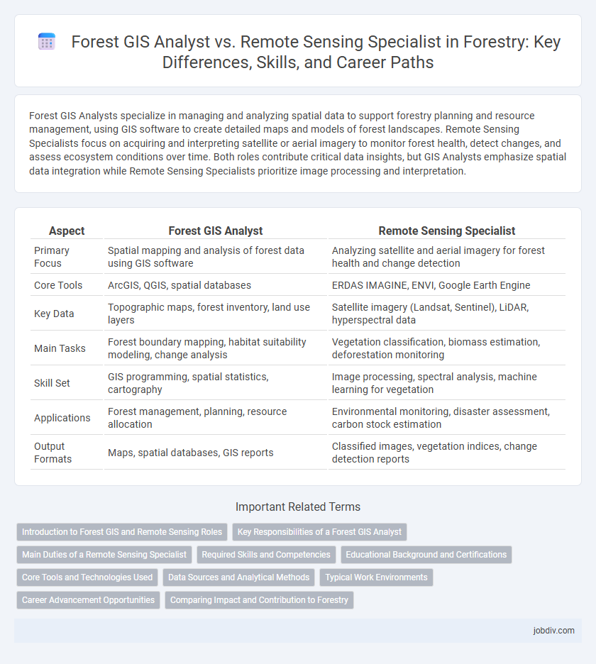
| Aspect | Forest GIS Analyst | Remote Sensing Specialist |
|---|---|---|
| Primary Focus | Spatial mapping and analysis of forest data using GIS software | Analyzing satellite and aerial imagery for forest health and change detection |
| Core Tools | ArcGIS, QGIS, spatial databases | ERDAS IMAGINE, ENVI, Google Earth Engine |
| Key Data | Topographic maps, forest inventory, land use layers | Satellite imagery (Landsat, Sentinel), LiDAR, hyperspectral data |
| Main Tasks | Forest boundary mapping, habitat suitability modeling, change analysis | Vegetation classification, biomass estimation, deforestation monitoring |
| Skill Set | GIS programming, spatial statistics, cartography | Image processing, spectral analysis, machine learning for vegetation |
| Applications | Forest management, planning, resource allocation | Environmental monitoring, disaster assessment, carbon stock estimation |
| Output Formats | Maps, spatial databases, GIS reports | Classified images, vegetation indices, change detection reports |
Introduction to Forest GIS and Remote Sensing Roles
Forest GIS Analysts specialize in managing and analyzing spatial forest data using Geographic Information Systems (GIS) to support sustainable forest management and resource planning. Remote Sensing Specialists focus on acquiring and interpreting aerial and satellite imagery to monitor forest health, land cover changes, and environmental impacts. Both roles utilize advanced geospatial technologies but emphasize different data sources and analytical techniques within forestry applications.
Key Responsibilities of a Forest GIS Analyst
A Forest GIS Analyst specializes in the collection, analysis, and management of spatial data related to forest ecosystems, utilizing Geographic Information Systems (GIS) to create detailed maps and models for sustainable forest management. Key responsibilities include interpreting satellite imagery, analyzing terrain and vegetation patterns, and supporting forest inventory and planning initiatives. This role requires expertise in spatial database management, cartographic design, and integrating GIS data with ecological and forestry models to inform decision-making.
Main Duties of a Remote Sensing Specialist
A Remote Sensing Specialist primarily processes and interprets satellite and aerial imagery to monitor forest health, detect changes in land cover, and assess biomass. They utilize advanced geospatial software and algorithms to analyze data collected from various remote sensing platforms such as LiDAR, multispectral, and hyperspectral sensors. Their expertise supports forest management by providing accurate spatial information for mapping, environmental monitoring, and resource assessment.
Required Skills and Competencies
A Forest GIS Analyst must possess expertise in geographic information systems (GIS) software such as ArcGIS and QGIS, spatial data management, and cartographic principles, along with strong analytical skills to interpret forest spatial data. In contrast, a Remote Sensing Specialist requires proficiency in remote sensing software like ENVI or ERDAS Imagine, understanding of satellite imagery processing, image classification techniques, and knowledge of sensor technologies used in forest monitoring. Both roles demand a solid foundation in forestry science, data accuracy assessment, and the ability to integrate spatial data for effective forest management decisions.
Educational Background and Certifications
A Forest GIS Analyst typically holds a degree in forestry, geography, or environmental science with strong expertise in Geographic Information Systems (GIS) and spatial data analysis. Remote Sensing Specialists often possess educational backgrounds in remote sensing, geoinformatics, or earth sciences, emphasizing expertise in satellite imagery interpretation and image processing software. Certifications such as GISP (Certified GIS Professional) for GIS Analysts and ASPRS (American Society for Photogrammetry and Remote Sensing) certifications for specialists enhance credibility and technical proficiency in their respective roles.
Core Tools and Technologies Used
Forest GIS Analysts primarily utilize Geographic Information Systems (GIS) platforms such as ArcGIS and QGIS for spatial data management, mapping, and analysis. Remote Sensing Specialists focus on processing and interpreting satellite imagery and aerial data using software like ENVI, ERDAS Imagine, and Google Earth Engine. Both roles integrate GPS technology and data from LiDAR sensors, but GIS Analysts emphasize spatial databases while Remote Sensing Specialists prioritize image classification and spectral analysis.
Data Sources and Analytical Methods
Forest GIS Analysts primarily utilize spatial data from satellite imagery, aerial photography, and topographic maps to perform geospatial analyses using software like ArcGIS and QGIS. Remote Sensing Specialists focus on processing and interpreting data obtained from LiDAR, multispectral, and hyperspectral sensors, employing image classification, spectral analysis, and machine learning techniques to monitor forest health and biomass. Both roles require expertise in data integration, but GIS Analysts emphasize map-based analytics while Remote Sensing Specialists concentrate on extracting quantitative information from raw sensor data.
Typical Work Environments
Forest GIS Analysts typically work in forestry departments, environmental consulting firms, and government agencies, utilizing geographic information systems (GIS) to manage and analyze spatial forest data. Remote Sensing Specialists are often found in research institutions, satellite data processing centers, and environmental monitoring organizations, focusing on interpreting aerial and satellite imagery to assess forest health and changes. Both roles frequently collaborate in field stations and offices equipped with advanced computer systems for data modeling and visualization.
Career Advancement Opportunities
Forest GIS Analysts experience career advancement by mastering spatial data management, cartography, and geographic information system software, making them essential for sustainable forest management and land-use planning. Remote Sensing Specialists progress through expertise in satellite and aerial imagery analysis, vegetation mapping, and change detection, enabling advanced monitoring of forest health and environmental impact. Both roles offer pathways to leadership positions in forestry research, resource management, and environmental consulting firms.
Comparing Impact and Contribution to Forestry
Forest GIS Analysts enhance forestry management by developing detailed spatial databases and performing advanced mapping to optimize resource allocation and monitor forest health. Remote Sensing Specialists contribute through analyzing satellite and aerial imagery to detect changes in forest cover, assess biomass, and identify disturbances such as disease outbreaks or deforestation. Both roles are critical; GIS Analysts provide precise spatial context and decision support tools, while Remote Sensing Specialists deliver timely, large-scale environmental data essential for strategic forestry planning and conservation efforts.
Forest GIS Analyst vs Remote Sensing Specialist Infographic