A Forest Inventory Analyst specializes in collecting and analyzing field data to assess forest composition, health, and growth trends, using statistical models to support sustainable management practices. A Remote Sensing Specialist leverages satellite imagery and aerial UAV data to monitor forest conditions over large areas, enabling rapid detection of changes such as deforestation or disease outbreaks. Both roles are essential for comprehensive forest management, combining ground truth data with advanced spatial analysis to optimize resource conservation.
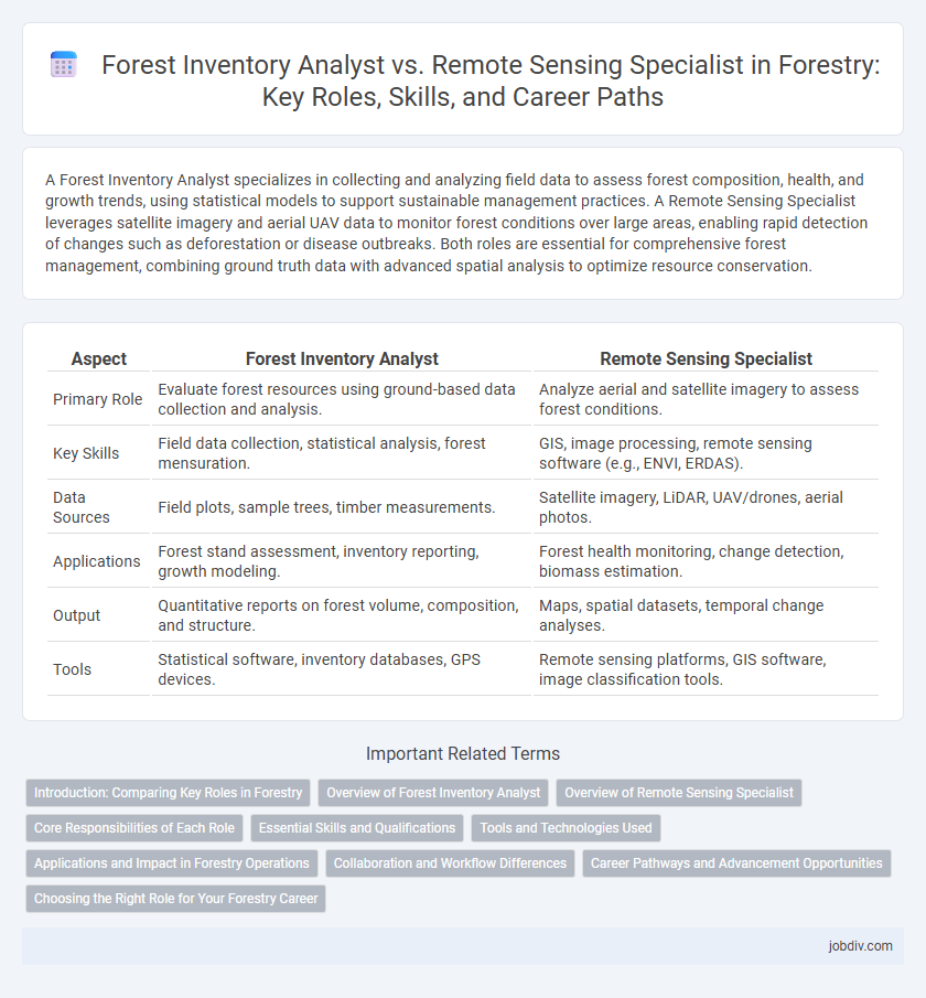
Table of Comparison
| Aspect | Forest Inventory Analyst | Remote Sensing Specialist |
|---|---|---|
| Primary Role | Evaluate forest resources using ground-based data collection and analysis. | Analyze aerial and satellite imagery to assess forest conditions. |
| Key Skills | Field data collection, statistical analysis, forest mensuration. | GIS, image processing, remote sensing software (e.g., ENVI, ERDAS). |
| Data Sources | Field plots, sample trees, timber measurements. | Satellite imagery, LiDAR, UAV/drones, aerial photos. |
| Applications | Forest stand assessment, inventory reporting, growth modeling. | Forest health monitoring, change detection, biomass estimation. |
| Output | Quantitative reports on forest volume, composition, and structure. | Maps, spatial datasets, temporal change analyses. |
| Tools | Statistical software, inventory databases, GPS devices. | Remote sensing platforms, GIS software, image classification tools. |
Introduction: Comparing Key Roles in Forestry
Forest Inventory Analysts specialize in collecting and analyzing quantitative data on forest composition, structure, and growth to inform sustainable management practices. Remote Sensing Specialists utilize satellite imagery, aerial photography, and LiDAR technology to monitor forest health, detect changes, and map vegetation patterns. Both roles are critical in forestry, with Inventory Analysts focusing on ground-based data accuracy and Remote Sensing Specialists providing large-scale, technological insights.
Overview of Forest Inventory Analyst
Forest Inventory Analysts specialize in collecting, analyzing, and interpreting data related to forest composition, growth, and health using field measurements and statistical models. They play a critical role in managing forest resources by providing accurate assessments to support sustainable forestry practices, timber harvesting, and conservation efforts. Proficiency in geographic information systems (GIS), data management, and forest measurement techniques distinguishes them from Remote Sensing Specialists, who primarily focus on satellite and aerial imagery analysis.
Overview of Remote Sensing Specialist
Remote Sensing Specialists in forestry utilize satellite imagery, LiDAR, and aerial photography to gather precise spatial data for assessing forest health, biomass, and changes over time. Their expertise in GIS technology and image processing enables detailed mapping and monitoring of forest ecosystems, supporting sustainable management and conservation efforts. Unlike Forest Inventory Analysts who rely more on ground-based measurements and statistical analysis, Remote Sensing Specialists emphasize automated, large-scale environmental data acquisition.
Core Responsibilities of Each Role
A Forest Inventory Analyst specializes in collecting, analyzing, and interpreting forest resource data to assess tree volume, growth, and health using ground-based inventory methods and statistical modeling. A Remote Sensing Specialist utilizes advanced technologies such as satellite imagery, LiDAR, and aerial photography to monitor forest conditions, detect changes in land cover, and support forestry management decisions through spatial data analysis. Both roles contribute critical data for sustainable forest management but differ in their methods: field data collection versus technology-driven remote observation.
Essential Skills and Qualifications
Forest Inventory Analysts possess strong skills in data collection, statistical analysis, and forest measurement techniques, with proficiency in GIS and advanced software like R or SQL for managing large datasets. Remote Sensing Specialists excel in interpreting satellite imagery, using tools such as ERDAS Imagine and ENVI, and applying machine learning algorithms to detect changes in forest health, land cover, and biomass. Both roles require knowledge of forest ecology and cartography, but Forest Inventory Analysts emphasize ground-based data accuracy while Remote Sensing Specialists prioritize spatial data processing and image interpretation.
Tools and Technologies Used
Forest Inventory Analysts primarily use Geographic Information Systems (GIS), Global Positioning Systems (GPS), and forestry-specific software like FIM and SilvaStat to collect and analyze timber volume, tree species, and growth data. Remote Sensing Specialists rely heavily on satellite imagery, LiDAR (Light Detection and Ranging), and unmanned aerial vehicles (UAVs or drones) equipped with multispectral and hyperspectral sensors to monitor forest health, land cover changes, and biomass estimation. Both roles utilize data analytics platforms but differ in tools, with inventory analysts focusing on ground-based measurements, while remote sensing specialists emphasize aerial and satellite data acquisition technologies.
Applications and Impact in Forestry Operations
Forest Inventory Analysts utilize ground-based data collection and statistical modeling to assess forest composition, volume, and health, enabling precise timber harvesting plans and sustainable resource management. Remote Sensing Specialists employ satellite imagery, LiDAR, and aerial surveys to monitor large-scale forest dynamics, detect disturbances, and support fire management and conservation efforts. Together, these roles integrate field data and advanced geospatial technologies to enhance decision-making accuracy and operational efficiency in forestry management.
Collaboration and Workflow Differences
Forest Inventory Analysts collaborate closely with field teams to collect and validate on-the-ground data, ensuring accurate forest resource assessments. Remote Sensing Specialists focus on analyzing satellite and aerial imagery, integrating geospatial technologies to interpret large-scale forest conditions. Their workflows differ as Inventory Analysts emphasize manual data collection and statistical analysis, while Remote Sensing Specialists utilize advanced GIS software and automated image processing for resource monitoring.
Career Pathways and Advancement Opportunities
Forest Inventory Analysts specialize in data collection and analysis related to forest resources, often advancing to roles in resource management or conservation planning. Remote Sensing Specialists focus on interpreting satellite and aerial imagery to monitor forest health, with career growth leading toward geospatial analysis or environmental consultancy. Both pathways offer advancement opportunities within governmental agencies, private forestry firms, and research institutions, with Remote Sensing Specialists generally experiencing higher demand due to technological integration in forest management.
Choosing the Right Role for Your Forestry Career
Forest Inventory Analysts specialize in collecting and analyzing data on forest composition, growth, and health using field measurements and statistical models to support sustainable forest management practices. Remote Sensing Specialists utilize satellite imagery, aerial photography, and GIS technologies to monitor large-scale forest conditions, detect changes, and assess environmental impacts with high spatial and temporal accuracy. Selecting the right forestry career depends on your skills in fieldwork and data analysis for Forest Inventory Analysts or expertise in geospatial technologies and image interpretation for Remote Sensing Specialists.
Forest Inventory Analyst vs Remote Sensing Specialist Infographic