GIS Analysts focus on managing and interpreting spatial data to create detailed maps and support forestry planning, emphasizing data integration and geographic information systems. Remote Sensing Specialists specialize in analyzing satellite and aerial imagery to monitor forest health, detect changes, and assess environmental impacts using advanced imaging technologies. Both roles are crucial in forestry management, with GIS Analysts providing spatial context and Remote Sensing Specialists offering precise environmental monitoring.
Table of Comparison
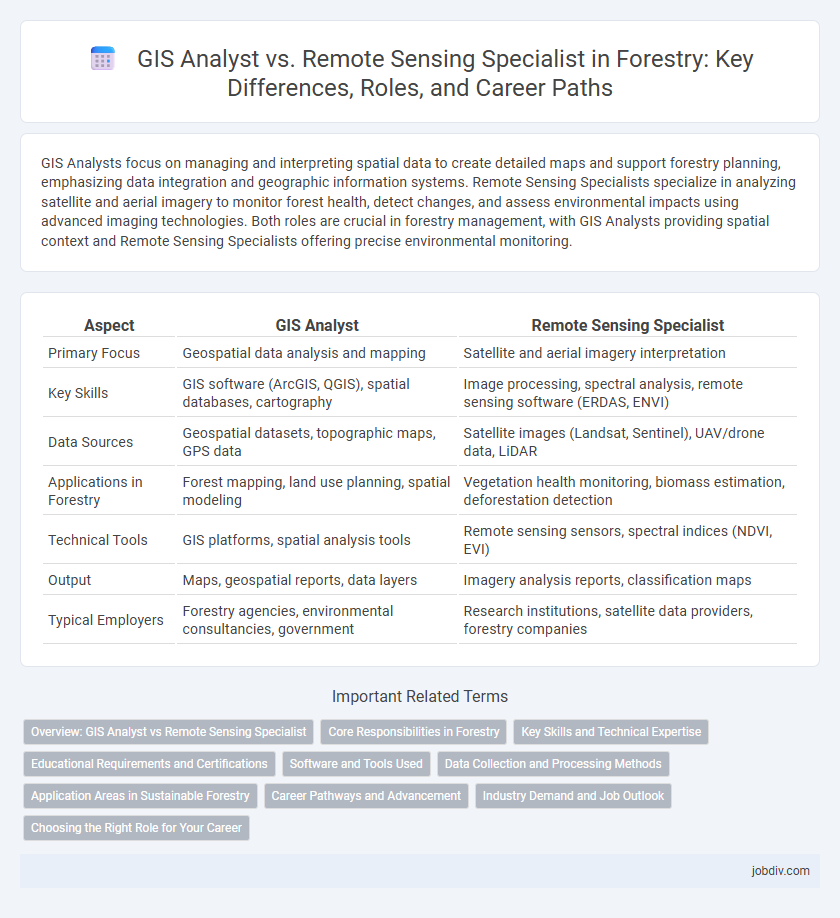
| Aspect | GIS Analyst | Remote Sensing Specialist |
|---|---|---|
| Primary Focus | Geospatial data analysis and mapping | Satellite and aerial imagery interpretation |
| Key Skills | GIS software (ArcGIS, QGIS), spatial databases, cartography | Image processing, spectral analysis, remote sensing software (ERDAS, ENVI) |
| Data Sources | Geospatial datasets, topographic maps, GPS data | Satellite images (Landsat, Sentinel), UAV/drone data, LiDAR |
| Applications in Forestry | Forest mapping, land use planning, spatial modeling | Vegetation health monitoring, biomass estimation, deforestation detection |
| Technical Tools | GIS platforms, spatial analysis tools | Remote sensing sensors, spectral indices (NDVI, EVI) |
| Output | Maps, geospatial reports, data layers | Imagery analysis reports, classification maps |
| Typical Employers | Forestry agencies, environmental consultancies, government | Research institutions, satellite data providers, forestry companies |
Overview: GIS Analyst vs Remote Sensing Specialist
GIS Analysts specialize in spatial data management, using Geographic Information Systems to analyze, visualize, and interpret forestry maps, land use patterns, and resource distribution. Remote Sensing Specialists focus on acquiring and processing satellite or aerial imagery to monitor forest health, detect changes in vegetation, and assess environmental impacts. Both roles integrate geospatial technologies but differ in data sources and analytical techniques, with GIS Analysts emphasizing data integration and modeling while Remote Sensing Specialists prioritize image acquisition and processing.
Core Responsibilities in Forestry
GIS Analysts in forestry primarily manage spatial data by creating, maintaining, and analyzing geospatial databases to support forest management and conservation planning. Remote Sensing Specialists focus on acquiring and interpreting aerial and satellite imagery to assess forest health, biomass, and changes over time. Both roles collaborate to integrate geospatial and remotely sensed data for informed decision-making in sustainable forest resource management.
Key Skills and Technical Expertise
GIS Analysts in forestry specialize in geographic data management, spatial analysis, and cartography using software like ArcGIS and QGIS to map forest resources and monitor land use changes. Remote Sensing Specialists focus on analyzing satellite and aerial imagery through tools such as ERDAS Imagine and ENVI to assess forest health, biomass, and disturbance patterns. Both roles require proficiency in data interpretation and modeling, with GIS Analysts emphasizing spatial database management and Remote Sensing Specialists excelling in image processing and spectral analysis.
Educational Requirements and Certifications
GIS Analysts in forestry typically require a bachelor's degree in geography, environmental science, or forestry with strong skills in Geographic Information Systems (GIS) software and spatial analysis. Remote Sensing Specialists often hold degrees in remote sensing, geospatial sciences, or forestry and must be proficient in satellite image interpretation, LiDAR data processing, and sensor technologies. Certifications such as GISP (Certified Geographic Information Systems Professional) for GIS Analysts and ASPRS Certified Photogrammetrist or Remote Sensing Technician credential for Remote Sensing Specialists enhance professional credibility and career opportunities.
Software and Tools Used
GIS Analysts in forestry primarily utilize software such as ArcGIS, QGIS, and GRASS GIS to create, manage, and analyze spatial data for mapping forest resources and planning management activities. Remote Sensing Specialists rely on tools like ENVI, ERDAS Imagine, and Google Earth Engine to process and interpret satellite imagery and aerial photographs for vegetation monitoring, biomass estimation, and detecting changes over time. Both roles often use programming languages such as Python and R to automate workflows and enhance data analysis accuracy.
Data Collection and Processing Methods
GIS Analysts in forestry primarily utilize Geographic Information Systems (GIS) to collect, store, and analyze spatial data derived from satellite imagery, aerial photos, and field surveys, employing tools such as ArcGIS and QGIS for detailed mapping and spatial pattern detection. Remote Sensing Specialists focus on acquiring and processing data from airborne and satellite sensors, using techniques like image classification, spectral analysis, and LiDAR processing to assess forest health, biomass estimation, and land cover changes. Both roles require proficiency in handling large datasets, but GIS Analysts emphasize spatial database management and visualization, while Remote Sensing Specialists specialize in sensor data interpretation and advanced image processing algorithms.
Application Areas in Sustainable Forestry
GIS Analysts in sustainable forestry excel at mapping forest cover, monitoring deforestation patterns, and planning conservation areas using spatial data analysis. Remote Sensing Specialists apply satellite imagery and aerial surveys to assess forest health, estimate biomass, and detect pest infestations with high precision. Both roles integrate geospatial technologies to support sustainable forest management, biodiversity conservation, and carbon stock assessments.
Career Pathways and Advancement
GIS Analysts in forestry specialize in spatial data management and mapping techniques, often advancing to roles such as GIS Manager or Spatial Data Scientist. Remote Sensing Specialists focus on acquiring and interpreting satellite or aerial imagery and typically progress toward positions like Remote Sensing Manager or Environmental Data Analyst. Both career paths offer opportunities to lead interdisciplinary teams and influence forest management decisions through advanced geospatial technologies.
Industry Demand and Job Outlook
GIS Analysts in forestry are experiencing strong industry demand due to their expertise in spatial data management and mapping, which supports sustainable forest management and conservation efforts. Remote Sensing Specialists are equally vital, as their skills in analyzing satellite and aerial imagery contribute to monitoring forest health, fire detection, and resource assessment. The job outlook for both roles remains positive, driven by increased reliance on geospatial technologies and environmental monitoring in forestry management.
Choosing the Right Role for Your Career
GIS analysts specialize in spatial data management and mapping techniques, utilizing software like ArcGIS to support forestry planning and resource management. Remote sensing specialists focus on interpreting satellite imagery and aerial data to monitor forest health, detect changes, and analyze vegetation patterns. Selecting the right career depends on your interest in hands-on spatial database development versus expertise in image processing and environmental monitoring technologies.
GIS Analyst vs Remote Sensing Specialist Infographic