A Forest Engineer designs and manages sustainable forest operations, focusing on timber harvesting, ecosystem conservation, and infrastructure development to maintain forest health. A GIS Specialist uses geographic information systems to analyze spatial data, creating detailed maps and models that support forest planning and resource management. Both roles collaborate to enhance forest management through technical expertise and data-driven decision-making.
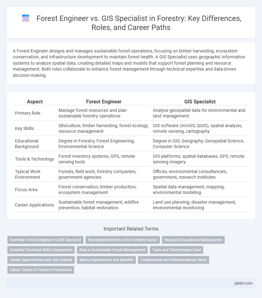
Table of Comparison
| Aspect | Forest Engineer | GIS Specialist |
|---|---|---|
| Primary Role | Manage forest resources and plan sustainable forestry operations | Analyze geospatial data for environmental and land management |
| Key Skills | Silviculture, timber harvesting, forest ecology, resource management | GIS software (ArcGIS, QGIS), spatial analysis, remote sensing, cartography |
| Educational Background | Degree in Forestry, Forest Engineering, Environmental Science | Degree in GIS, Geography, Geospatial Science, Computer Science |
| Tools & Technology | Forest inventory systems, GPS, remote sensing tools | GIS platforms, spatial databases, GPS, remote sensing imagery |
| Typical Work Environment | Forests, field work, forestry companies, government agencies | Offices, environmental consultancies, government, research institutes |
| Focus Area | Forest conservation, timber production, ecosystem management | Spatial data management, mapping, environmental modeling |
| Career Applications | Sustainable forest management, wildfire prevention, habitat restoration | Land use planning, disaster management, environmental monitoring |
Overview: Forest Engineer vs GIS Specialist
Forest engineers apply principles of engineering, biology, and forestry to design and implement sustainable forest management practices, focusing on land use planning, erosion control, and timber harvesting techniques. GIS specialists in forestry utilize geographic information systems to capture, analyze, and visualize spatial data, supporting decision-making in forest inventory, habitat analysis, and resource monitoring. While forest engineers integrate ecological and engineering knowledge for practical forest operations, GIS specialists provide critical spatial insights that optimize forest management and conservation strategies.
Key Responsibilities in the Forestry Sector
Forest Engineers design and implement sustainable forest management plans, focusing on timber harvesting, soil conservation, and reforestation techniques to optimize forest resources while minimizing environmental impact. GIS Specialists analyze and manage spatial data to create detailed maps and models, supporting decision-making in forest inventory, wildlife habitat assessment, and land-use planning. Both roles collaborate to enhance forest monitoring and resource allocation, blending engineering principles with advanced geospatial technologies.
Required Educational Backgrounds
A Forest Engineer typically requires a bachelor's degree in forestry, forest engineering, or natural resource management, emphasizing subjects like forest ecology, soil science, and timber harvesting techniques. In contrast, a GIS Specialist often holds a degree in geography, computer science, or environmental science, focusing on spatial analysis, cartography, and geospatial technologies such as ArcGIS and remote sensing. Both careers benefit from coursework in environmental regulations and data analysis, but the Forest Engineer leans more toward applied ecosystem management, while the GIS Specialist centers on spatial data interpretation and mapping.
Essential Technical Skills Comparison
Forest Engineers require expertise in silviculture, forest inventory, and land management software to design sustainable forestry operations. GIS Specialists must master spatial analysis, remote sensing, and GIS software such as ArcGIS and QGIS for mapping and data visualization. Both professionals benefit from strong knowledge of GPS technology and data integration techniques to support forestry decision-making.
Role in Sustainable Forest Management
Forest engineers integrate principles of ecology, soil science, and hydrology to design and implement sustainable forest management plans that balance timber production with conservation goals. GIS specialists provide critical spatial analysis and mapping capabilities, enabling precise monitoring of forest health, biodiversity, and resource distribution to support informed decision-making. Collaboration between forest engineers and GIS specialists enhances habitat protection, wildfire risk assessment, and sustainable harvesting practices through advanced geospatial data integration.
Tools and Technologies Used
Forest Engineers utilize tools such as GPS devices, drones, remote sensing technology, and specialized software like AutoCAD and ArcGIS to design and manage sustainable forestry operations. GIS Specialists focus primarily on geographic information systems software including ArcGIS, QGIS, and spatial databases to analyze spatial data and generate detailed forest maps and resource inventories. Both professionals rely on satellite imagery and LiDAR technology to enhance forest monitoring, but Forest Engineers integrate these tools with engineering principles for planning infrastructure and conservation projects.
Career Opportunities and Job Outlook
Forest engineers design and manage sustainable forest operations, with career opportunities in timber production companies, government forestry agencies, and environmental consulting firms, reflecting steady job growth driven by increasing demand for sustainable resource management. GIS specialists in forestry utilize spatial data and mapping technologies to support forest planning, conservation, and wildfire management, experiencing strong job outlooks due to the expanding use of geospatial analysis in natural resource management. Both professions benefit from advancements in technology and environmental policies that prioritize sustainable forest management and land-use planning.
Salary Expectations and Benefits
Forest Engineers typically earn an average salary ranging from $60,000 to $85,000 annually, with benefits such as fieldwork allowances, health insurance, and retirement plans tailored to outdoor and environmental roles. GIS Specialists in forestry command salaries between $55,000 and $80,000 per year, often receiving benefits that include professional development opportunities, software access, and remote work flexibility. Salary expectations in both roles vary by region, experience level, and employer type, with GIS Specialists sometimes having higher earning potential in tech-focused forestry projects.
Collaboration and Interdisciplinary Work
Forest engineers and GIS specialists collaborate closely to optimize forest management by integrating spatial data analysis with engineering principles. This interdisciplinary partnership enhances decision-making in reforestation, conservation, and infrastructure planning through accurate mapping and terrain assessment. Combining expertise in ecology, hydrology, and geospatial technology fosters innovative solutions for sustainable forestry practices.
Future Trends in Forestry Professions
Forest engineers are increasingly integrating remote sensing and drone technology to enhance sustainable forest management, while GIS specialists focus on advanced spatial data analytics and machine learning to optimize resource mapping. Emerging trends point to a convergence where both professions leverage AI-driven decision support systems to address climate resilience and biodiversity conservation. Proficiency in big data, geospatial technologies, and environmental modeling will define the future skill set for forestry professionals.
Forest Engineer vs GIS Specialist Infographic