GIS Specialists in forestry utilize Geographic Information Systems to collect, analyze, and visualize spatial data for forest management and planning. Remote Sensing Analysts focus on interpreting satellite and aerial imagery to monitor forest health, detect changes, and support conservation efforts. Both roles are essential for effective forest resource management, offering complementary skills in spatial data analysis and environmental monitoring.
Table of Comparison
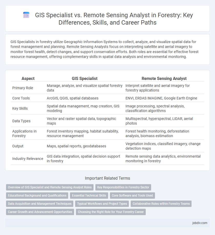
| Aspect | GIS Specialist | Remote Sensing Analyst |
|---|---|---|
| Primary Role | Manage, analyze, and visualize spatial forestry data | Interpret satellite and aerial imagery for forestry applications |
| Core Tools | ArcGIS, QGIS, spatial databases | ENVI, ERDAS IMAGINE, Google Earth Engine |
| Key Skills | Spatial data management, map creation, GIS modeling | Image processing, spectral analysis, classification algorithms |
| Data Types | Vector and raster spatial data, topographic maps | Multispectral, hyperspectral, LiDAR, aerial photos |
| Applications in Forestry | Forest inventory mapping, habitat suitability, resource management | Forest health monitoring, deforestation analysis, biomass estimation |
| Output | Maps, spatial reports, geodatabases | Vegetation indices, classified imagery, change detection maps |
| Industry Relevance | GIS data integration, spatial decision support in forestry | Remote sensing data analytics, environmental monitoring in forestry |
Overview of GIS Specialist and Remote Sensing Analyst Roles
GIS Specialists manage and analyze spatial data to create detailed maps and support decision-making in forestry management, utilizing software like ArcGIS to monitor forest health and land use. Remote Sensing Analysts focus on interpreting aerial and satellite imagery to detect changes in forest cover, assess biodiversity, and evaluate environmental conditions using tools such as ENVI or ERDAS Imagine. Both roles integrate geospatial technologies but emphasize different data sources and analytical approaches critical for sustainable forest resource management.
Key Responsibilities in Forestry Sector
GIS Specialists in forestry manage spatial data, create detailed forest maps, analyze land use patterns, and support sustainable forest management through geographic information systems. Remote Sensing Analysts focus on interpreting satellite and aerial imagery to monitor forest health, detect deforestation, assess biomass, and track changes over time. Both roles collaborate to enhance forest conservation efforts, resource inventory, and wildfire risk assessment using advanced geospatial technologies.
Educational Background and Qualifications
A GIS Specialist in forestry typically holds a degree in Geography, Environmental Science, or Geographical Information Systems, with expertise in spatial data management and cartographic techniques. In contrast, a Remote Sensing Analyst often has a background in Remote Sensing, Geomatics, or Earth Sciences, emphasizing knowledge in satellite imagery interpretation, sensor technology, and image processing software. Both roles require proficiency in software such as ArcGIS for GIS Specialists and ENVI or ERDAS Imagine for Remote Sensing Analysts, along with strong analytical and technical skills.
Essential Technical Skills
A GIS Specialist in forestry must excel in spatial data management, proficiency in software like ArcGIS, and expertise in geospatial database design to support forest inventory and management. A Remote Sensing Analyst requires advanced skills in processing satellite and aerial imagery, using tools such as ENVI or ERDAS Imagine, and applying spectral analysis to monitor forest health and biomass. Both roles demand strong knowledge of coordinate systems and data integration but diverge in their core technical focus--GIS Specialists emphasize spatial data infrastructure, while Remote Sensing Analysts concentrate on image processing and interpretation.
Core Software and Tools Used
GIS Specialists primarily use software such as ArcGIS, QGIS, and GRASS GIS for spatial data analysis, mapping, and geospatial database management in forestry applications. Remote Sensing Analysts rely heavily on tools like ENVI, ERDAS IMAGINE, and Google Earth Engine to process and interpret satellite imagery and aerial photographs for forest monitoring and assessment. Both roles often integrate Python or R for advanced spatial analysis and automation, enhancing precision and efficiency in forestry resource management.
Data Acquisition and Management Techniques
A GIS Specialist specializes in spatial data acquisition through GPS technologies, satellite imagery integration, and field surveys, focusing on organizing and managing geographic information systems for efficient data storage and retrieval. A Remote Sensing Analyst utilizes advanced sensor data from airborne or satellite platforms, applying image processing techniques to extract meaningful environmental information and monitor forest health. Both roles require proficiency in data validation, quality control, and database management to support accurate forest resource assessments and decision-making.
Typical Workflows and Project Types
GIS Specialists in forestry typically manage spatial databases, perform land use mapping, and create detailed forest inventory maps using Geographic Information Systems software. Remote Sensing Analysts process satellite or aerial imagery to monitor forest health, detect deforestation, and analyze vegetation changes over time through image classification and spectral analysis. Projects for GIS Specialists often involve habitat suitability modeling and forest management planning, while Remote Sensing Analysts focus on wildfire detection, biomass estimation, and change detection in forest cover.
Collaborative Roles within Forestry Teams
GIS Specialists enhance forestry teams by managing spatial data and creating detailed maps that guide resource management and conservation planning. Remote Sensing Analysts provide critical insights through processing satellite and aerial imagery to monitor forest health, detect changes, and assess biomass. Their collaborative roles ensure comprehensive analysis, combining geospatial data expertise with advanced image interpretation to support sustainable forestry practices.
Career Growth and Advancement Opportunities
GIS Specialists in forestry leverage geographic information systems to create detailed maps and spatial data models that assist in resource management, often progressing into roles such as GIS Manager or Spatial Data Scientist. Remote Sensing Analysts focus on interpreting satellite or aerial imagery to monitor forest health and changes, with career paths leading to positions like Remote Sensing Project Lead or Environmental Data Analyst. Both fields offer strong advancement opportunities driven by increasing demand for precise environmental data and technological integration in forest conservation and management.
Choosing the Right Role for Your Forestry Career
GIS Specialists in forestry focus on spatial data management, creating detailed maps, and analyzing geographic information to support forest planning and management. Remote Sensing Analysts utilize satellite imagery and aerial data to monitor forest health, detect changes, and assess environmental impacts over time. Choosing the right role depends on your interest in hands-on spatial data processing (GIS Specialist) versus image analysis and interpretation (Remote Sensing Analyst) within forestry applications.
GIS Specialist vs Remote Sensing Analyst Infographic