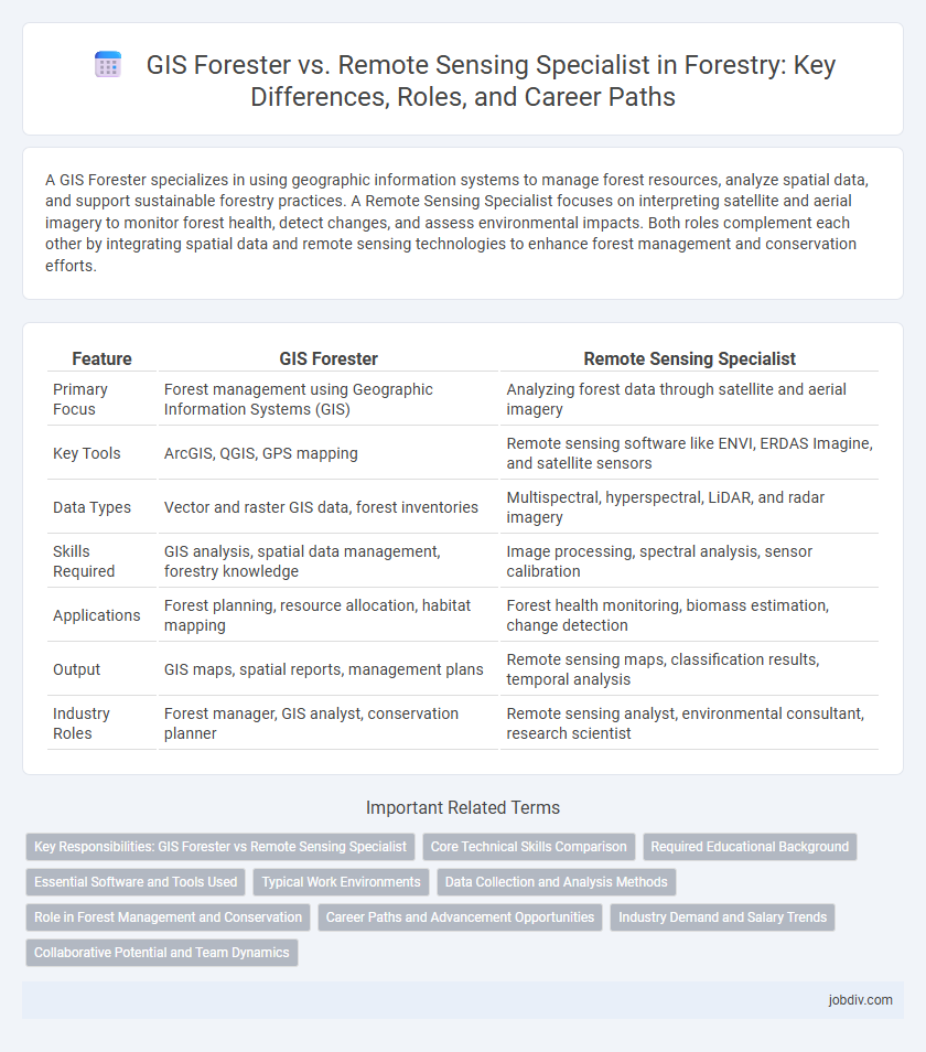
A GIS Forester specializes in using geographic information systems to manage forest resources, analyze spatial data, and support sustainable forestry practices. A Remote Sensing Specialist focuses on interpreting satellite and aerial imagery to monitor forest health, detect changes, and assess environmental impacts. Both roles complement each other by integrating spatial data and remote sensing technologies to enhance forest management and conservation efforts.
Table of Comparison
| Feature | GIS Forester | Remote Sensing Specialist |
|---|---|---|
| Primary Focus | Forest management using Geographic Information Systems (GIS) | Analyzing forest data through satellite and aerial imagery |
| Key Tools | ArcGIS, QGIS, GPS mapping | Remote sensing software like ENVI, ERDAS Imagine, and satellite sensors |
| Data Types | Vector and raster GIS data, forest inventories | Multispectral, hyperspectral, LiDAR, and radar imagery |
| Skills Required | GIS analysis, spatial data management, forestry knowledge | Image processing, spectral analysis, sensor calibration |
| Applications | Forest planning, resource allocation, habitat mapping | Forest health monitoring, biomass estimation, change detection |
| Output | GIS maps, spatial reports, management plans | Remote sensing maps, classification results, temporal analysis |
| Industry Roles | Forest manager, GIS analyst, conservation planner | Remote sensing analyst, environmental consultant, research scientist |
Key Responsibilities: GIS Forester vs Remote Sensing Specialist
GIS Foresters primarily manage spatial data related to forest inventory, vegetation mapping, and land-use planning using Geographic Information Systems to support sustainable forest management practices. Remote Sensing Specialists focus on acquiring and analyzing satellite and aerial imagery to monitor forest health, detect changes in canopy cover, and assess post-disturbance recovery. Both roles collaborate to integrate spatial and spectral data, enhancing precision in forest resource assessment and decision-making processes.
Core Technical Skills Comparison
GIS Foresters excel in spatial data analysis, forest inventory mapping, and land management using Geographic Information Systems (GIS) software such as ArcGIS and QGIS. Remote Sensing Specialists specialize in interpreting satellite imagery and aerial photographs, utilizing tools like ENVI and ERDAS Imagine to analyze vegetation health, biomass estimation, and change detection. Both roles require proficiency in spatial data processing, but GIS Foresters emphasize land use planning and forest resource management, while Remote Sensing Specialists focus on image classification, spectral analysis, and temporal data monitoring.
Required Educational Background
A GIS Forester typically requires a degree in forestry, environmental science, or geography with strong skills in geographic information systems (GIS) and spatial data analysis. A Remote Sensing Specialist often holds a background in geospatial science, remote sensing, or computer science, emphasizing expertise in satellite imagery interpretation, image processing, and sensor technologies. Both roles demand proficiency in spatial data management but differ in their technical focus and academic training.
Essential Software and Tools Used
GIS Foresters primarily use software like ArcGIS, QGIS, and Forest Vegetation Simulator for spatial analysis, forest inventory, and management planning. Remote Sensing Specialists rely heavily on tools such as ENVI, ERDAS IMAGINE, and Google Earth Engine to process satellite imagery, perform vegetation indexing, and monitor forest health. Both roles utilize GPS devices and data management systems but differ in their emphasis on spatial data visualization versus image processing techniques.
Typical Work Environments
GIS Foresters typically work in field offices, forestry departments, and environmental consulting firms where they analyze spatial data to support forest management and conservation. Remote Sensing Specialists often operate in research institutions, government agencies, and satellite data centers, focusing on processing satellite and aerial imagery for vegetation health and land cover analysis. Both roles require collaboration with environmental scientists and use of geospatial technology, but GIS Foresters are more engaged with on-the-ground forest conditions while Remote Sensing Specialists emphasize automated data interpretation from remote platforms.
Data Collection and Analysis Methods
GIS Foresters primarily utilize Geographic Information Systems to collect, manage, and analyze spatial forest data, integrating satellite imagery, topographic maps, and field surveys to support forest inventory and management. Remote Sensing Specialists focus on acquiring and interpreting aerial and satellite sensor data, employing techniques such as LiDAR, multispectral, and hyperspectral imaging to assess forest health, biomass, and canopy structure. Both roles emphasize accuracy in data processing, but GIS Foresters integrate diverse datasets for spatial modeling, while Remote Sensing Specialists concentrate on advanced sensor data analysis for ecological monitoring.
Role in Forest Management and Conservation
A GIS Forester specializes in spatial data analysis and mapping to support forest inventory, planning, and resource management, enabling precise monitoring of forest health and timber resources. A Remote Sensing Specialist utilizes satellite and aerial imagery to detect changes in forest cover, assess biodiversity, and monitor environmental impacts, providing critical data for conservation efforts. Together, these roles integrate geospatial technologies to enhance decision-making and promote sustainable forest management.
Career Paths and Advancement Opportunities
GIS Foresters specialize in spatial analysis and mapping of forest resources, leveraging Geographic Information Systems to support sustainable forest management and conservation efforts. Remote Sensing Specialists focus on interpreting satellite and aerial imagery to monitor forest health, detect changes, and analyze environmental impacts, using advanced sensors and image processing techniques. Career advancement for GIS Foresters often leads to roles in resource management and planning, while Remote Sensing Specialists may progress toward research, technology development, and environmental monitoring leadership positions.
Industry Demand and Salary Trends
GIS Foresters typically command higher salaries due to their specialized expertise in spatial data management and forest inventory analysis, with industry demand growing at a steady rate of 5% annually. Remote Sensing Specialists see rising demand driven by advances in satellite and drone technology, offering competitive salaries that have increased by approximately 7% over the past five years. Both roles are critical in forestry, but GIS Foresters often have broader applications, leading to more consistent employment opportunities.
Collaborative Potential and Team Dynamics
GIS Foresters and Remote Sensing Specialists enhance forestry projects through complementary expertise, where GIS Foresters analyze spatial data for forest management, while Remote Sensing Specialists interpret satellite and aerial imagery for vegetation health and land change detection. Their collaboration fosters robust data integration, enabling precise decision-making and effective resource allocation within forest ecosystems. Synergistic team dynamics emerge from their shared focus on geospatial technologies, driving innovative solutions in sustainable forestry practices.
GIS Forester vs Remote Sensing Specialist Infographic