Utility locators detect and mark underground utilities by directly tracing signals emitted from pipes or cables, ensuring precise identification of specific utility lines. Utility mappers create detailed maps of underground infrastructure using electromagnetic or ground-penetrating radar technology, providing comprehensive spatial data for planning and excavation. Choosing between a locator and a mapper depends on the required accuracy and scope of the utility detection project.
Table of Comparison
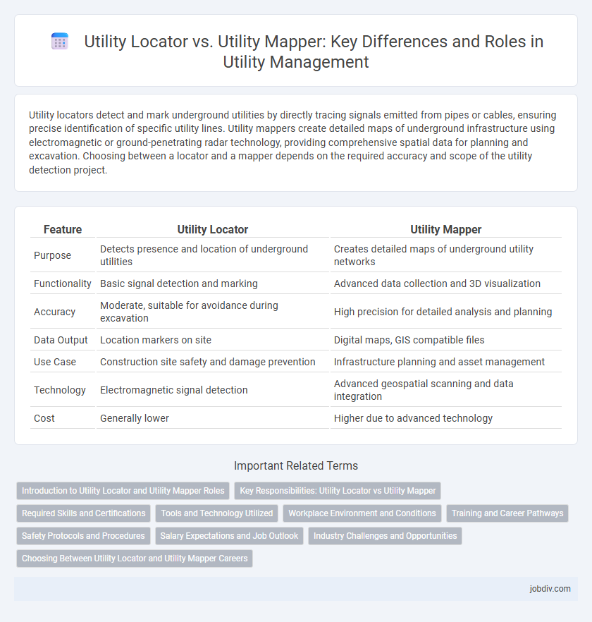
| Feature | Utility Locator | Utility Mapper |
|---|---|---|
| Purpose | Detects presence and location of underground utilities | Creates detailed maps of underground utility networks |
| Functionality | Basic signal detection and marking | Advanced data collection and 3D visualization |
| Accuracy | Moderate, suitable for avoidance during excavation | High precision for detailed analysis and planning |
| Data Output | Location markers on site | Digital maps, GIS compatible files |
| Use Case | Construction site safety and damage prevention | Infrastructure planning and asset management |
| Technology | Electromagnetic signal detection | Advanced geospatial scanning and data integration |
| Cost | Generally lower | Higher due to advanced technology |
Introduction to Utility Locator and Utility Mapper Roles
Utility locators identify and mark the precise locations of underground utilities such as water, gas, electric, and telecom lines to prevent damage during excavation. Utility mappers collect detailed spatial data to create accurate maps and models of utility networks, enabling better planning and management. Both roles are essential in infrastructure projects to ensure safety, reduce costs, and improve efficiency.
Key Responsibilities: Utility Locator vs Utility Mapper
Utility Locators primarily focus on detecting and marking underground utilities such as gas, water, electrical, and communication lines to prevent damage during excavation. Utility Mappers specialize in creating detailed maps and GIS data of utility networks, ensuring accurate documentation and spatial analysis for planning and maintenance. Both roles require expertise in utility detection technologies, but locators emphasize field detection while mappers concentrate on data integration and visualization.
Required Skills and Certifications
Utility locators possess specialized skills in underground utility detection, utilizing electromagnetic and ground-penetrating radar technologies to accurately identify and mark utility lines. Utility mappers require advanced proficiency in GIS software, survey techniques, and data analysis to create detailed, spatially accurate records of utility infrastructure, often necessitating certifications like GIS Professional (GISP) and specialized surveying licenses. Both roles demand thorough knowledge of safety protocols and regulatory compliance, with locators emphasizing hands-on detection skills and mappers focusing on data mapping and interpretation expertise.
Tools and Technology Utilized
Utility locators primarily use electromagnetic detection tools, ground-penetrating radar (GPR), and radio frequency scanners to identify and mark underground utility lines accurately. Utility mappers employ advanced technologies such as 3D mapping software, GPS integration, and GIS (Geographic Information Systems) to create detailed utility maps that offer spatial analysis and comprehensive utility network visualization. Both rely on high-precision sensors and data processing techniques, but utility mappers focus more on data integration and geospatial accuracy for infrastructure planning and management.
Workplace Environment and Conditions
Utility locators operate primarily in surface-level environments, using ground-penetrating radar and electromagnetic signals to detect and mark underground utilities in varied workplace conditions such as construction sites and urban areas. Utility mappers engage in more complex environments, employing advanced geospatial technology and GPS integration to create detailed maps of utility networks for infrastructure planning and maintenance. Both roles demand adaptability to weather, terrain, and safety protocols to ensure accurate data collection and operational efficiency.
Training and Career Pathways
Utility locators receive focused training on identifying and marking underground utilities using electromagnetic and ground-penetrating radar technologies, preparing them for entry-level roles in construction and infrastructure maintenance. Utility mappers undergo advanced training in geographic information systems (GIS), 3D modeling, and spatial data analysis, which opens career pathways in urban planning, civil engineering, and asset management. Progression from utility locator to mapper often involves continuous education and certification, enhancing technical expertise and career advancement opportunities within the utility sector.
Safety Protocols and Procedures
Utility locators and utility mappers differ significantly in their safety protocols and procedures; utility locators follow strict on-site identification processes to prevent accidental strikes of underground utilities, relying on calibrated electromagnetic detection tools and adherence to OSHA excavation safety standards. Utility mappers employ advanced geospatial technologies such as GIS and 3D mapping, integrating comprehensive data validation steps to ensure accuracy and reduce human error during infrastructure planning. Both prioritize worker and public safety by implementing rigorous training programs, real-time risk assessments, and compliance with local utility regulations and hazard communication requirements.
Salary Expectations and Job Outlook
Utility Locators typically earn between $40,000 and $60,000 annually, reflecting entry to mid-level positions focused on underground asset detection. Utility Mappers, leveraging advanced geospatial technologies and data analysis, command higher salaries ranging from $55,000 to $75,000, with job growth projected at 8% due to increasing infrastructure projects. Demand for skilled Utility Mappers is outpacing Locators as industries prioritize precise mapping for urban planning and construction safety.
Industry Challenges and Opportunities
Utility locators face challenges in accurately detecting underground assets due to signal interference and complex soil conditions, leading to costly project delays and safety risks. Utility mappers offer enhanced precision by integrating advanced technologies like GIS and 3D mapping, enabling detailed asset visualization and data management. The industry opportunity lies in adopting hybrid solutions that combine locator speed with mapper accuracy to improve infrastructure planning and reduce excavation hazards.
Choosing Between Utility Locator and Utility Mapper Careers
Utility Locator careers focus on accurately identifying underground utilities using electromagnetic or ground-penetrating radar technology, ensuring safety during construction and excavation projects. Utility Mapper professionals specialize in creating detailed maps of utility networks, often integrating GIS data for comprehensive asset management and infrastructure planning. Choosing between these careers depends on preference for fieldwork involving detection and data collection versus analytical skills in cartography and spatial data interpretation.
Utility Locator vs Utility Mapper Infographic