Surface water modelers specialize in simulating rivers, lakes, and streams to predict flow patterns and assess flood risks, while groundwater modelers focus on subsurface water movement to evaluate aquifer behavior and contamination spread. Both use hydrological data and computational tools but apply different methodologies suited to either surface or underground water systems. Understanding the distinctions between these roles enhances water resource management and environmental planning efforts.
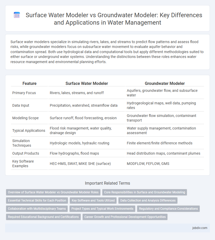
Table of Comparison
| Feature | Surface Water Modeler | Groundwater Modeler |
|---|---|---|
| Primary Focus | Rivers, lakes, streams, and runoff | Aquifers, groundwater flow, and subsurface water |
| Data Input | Precipitation, watershed, streamflow data | Hydrogeological maps, well data, pumping rates |
| Modeling Scope | Surface runoff, flood forecasting, erosion | Groundwater flow simulation, contaminant transport |
| Typical Applications | Flood risk management, water quality, drainage design | Water supply management, contamination assessment |
| Simulation Techniques | Hydrologic models, hydraulic routing | Finite element/finite difference methods |
| Output Products | Flow hydrographs, flood maps | Head distribution maps, contaminant plumes |
| Key Software Examples | HEC-HMS, SWAT, MIKE SHE (surface) | MODFLOW, FEFLOW, GMS |
Overview of Surface Water Modeler vs Groundwater Modeler Roles
Surface water modelers analyze the behavior and movement of water in rivers, lakes, and reservoirs, using tools like hydrodynamic and hydraulic models to predict flood risks and manage stormwater systems. Groundwater modelers focus on subsurface water flow within aquifers, employing groundwater flow simulators to assess contamination risks, groundwater recharge, and extraction sustainability. Both roles require expertise in hydrology and environmental engineering but differ in their data inputs and the specific challenges of surface versus subsurface water management.
Core Responsibilities in Surface and Groundwater Modeling
Surface Water Modelers primarily analyze river, lake, and stream flows to predict flood risks, manage stormwater, and support watershed management using hydrodynamic and hydraulic models. Groundwater Modelers focus on subsurface water flow, contaminant transport, and aquifer recharge by utilizing geological and hydrogeological data with numerical simulation tools. Both roles require integrating spatial data and hydrological processes to ensure sustainable water resource management.
Essential Technical Skills for Each Position
Surface Water Modelers require proficiency in hydrodynamic modeling software such as HEC-RAS and MIKE 21, strong skills in GIS for spatial analysis, and expertise in analyzing river flow, floodplain mapping, and stormwater management. Groundwater Modelers need advanced knowledge of subsurface hydrology, experience with groundwater modeling tools like MODFLOW and GMS, and the ability to interpret aquifer properties, contaminant transport, and groundwater-surface water interactions. Both roles demand strong data analysis capabilities and a solid understanding of hydrological cycle principles to develop accurate predictive models.
Key Software and Tools Utilized
Surface Water Modelers primarily utilize software such as HEC-RAS, SWMM, and MIKE 21 to simulate river hydraulics, urban drainage, and coastal processes, enabling detailed analysis of flow dynamics and flood risks. Groundwater Modelers rely heavily on tools like MODFLOW, FEFLOW, and Groundwater Vistas to simulate subsurface flow, aquifer properties, and contaminant transport, facilitating accurate prediction of groundwater availability and quality. Both disciplines increasingly integrate GIS platforms like ArcGIS for spatial data analysis and visualization, enhancing model precision and decision-making.
Data Collection and Analysis Differences
Surface water modelers gather data primarily from river flows, precipitation, and watershed runoff, utilizing remote sensing and stream gauges to capture dynamic surface conditions. Groundwater modelers focus on subsurface data collection, including aquifer properties, well logs, and hydraulic conductivity, often relying on borehole testing and groundwater sampling for accurate analysis. Analytical approaches for surface water emphasize real-time flow variability, while groundwater modeling prioritizes long-term aquifer behavior and recharge rates.
Collaboration with Multidisciplinary Teams
Surface Water Modelers and Groundwater Modelers collaborate closely within multidisciplinary teams, integrating hydrologic, geologic, and environmental data to simulate water flow and quality accurately. Their combined expertise supports comprehensive water resource management, enabling the design of sustainable infrastructure and effective pollution control strategies. Effective communication and data sharing between these specialists enhance the precision of watershed and aquifer models.
Project Types and Typical Work Environments
Surface Water Modelers primarily work on projects involving rivers, lakes, and floodplains, focusing on hydrodynamic simulations and flood risk assessments. Groundwater Modelers handle subsurface projects such as aquifer recharge, contaminant transport, and wellfield management, often utilizing numerical models like MODFLOW. Work environments for Surface Water Modelers typically include field sites and offices near surface water sources, while Groundwater Modelers often operate in laboratory settings and hydrogeological research facilities.
Regulatory and Compliance Considerations
Surface water modelers must prioritize regulatory compliance related to stormwater management and floodplain delineation under agencies like the EPA and local environmental authorities. Groundwater modelers focus on contamination risk assessments and aquifer sustainability complying with regulations from the U.S. Geological Survey (USGS) and state-level water quality standards. Both roles require adherence to the Clean Water Act and specific permits ensuring accurate simulation of hydrological processes to meet legal and environmental protection mandates.
Required Educational Background and Certifications
Surface water modelers typically require a bachelor's or master's degree in hydrology, civil or environmental engineering, or related fields, with certifications such as Certified Professional in Watershed Management (CPWM) enhancing career prospects. Groundwater modelers often hold advanced degrees in hydrogeology, geology, or environmental science, and obtaining certifications like the Professional Geologist (PG) or Certified Groundwater Professional (CGWP) demonstrates expertise in subsurface water modeling. Both roles benefit from strong analytical skills and proficiency in specialized modeling software, aligning with industry standards and regulatory requirements.
Career Growth and Professional Development Opportunities
Surface Water Modelers often experience rapid career growth by working on large-scale projects involving river systems, floodplain mapping, and watershed management, which are critical for urban planning and disaster mitigation. Groundwater Modelers gain specialized expertise in hydrogeology, aquifer testing, and contaminant transport, leading to niche roles in environmental consulting, water resource management, and regulatory compliance. Both paths offer professional development through advanced certifications, software proficiency in tools like HEC-RAS for surface water and MODFLOW for groundwater, and opportunities to contribute to sustainable water resources planning.
Surface Water Modeler vs Groundwater Modeler Infographic