A land surveyor specializes in measuring and mapping land boundaries using advanced surveying instruments to ensure legal property descriptions and construction site accuracy. A geomatics technician supports this process by collecting, analyzing, and managing spatial data through geographic information systems (GIS) and remote sensing technology. Both roles are essential in construction for accurate land assessment, but the surveyor typically holds a professional license and performs higher-level field and office duties.
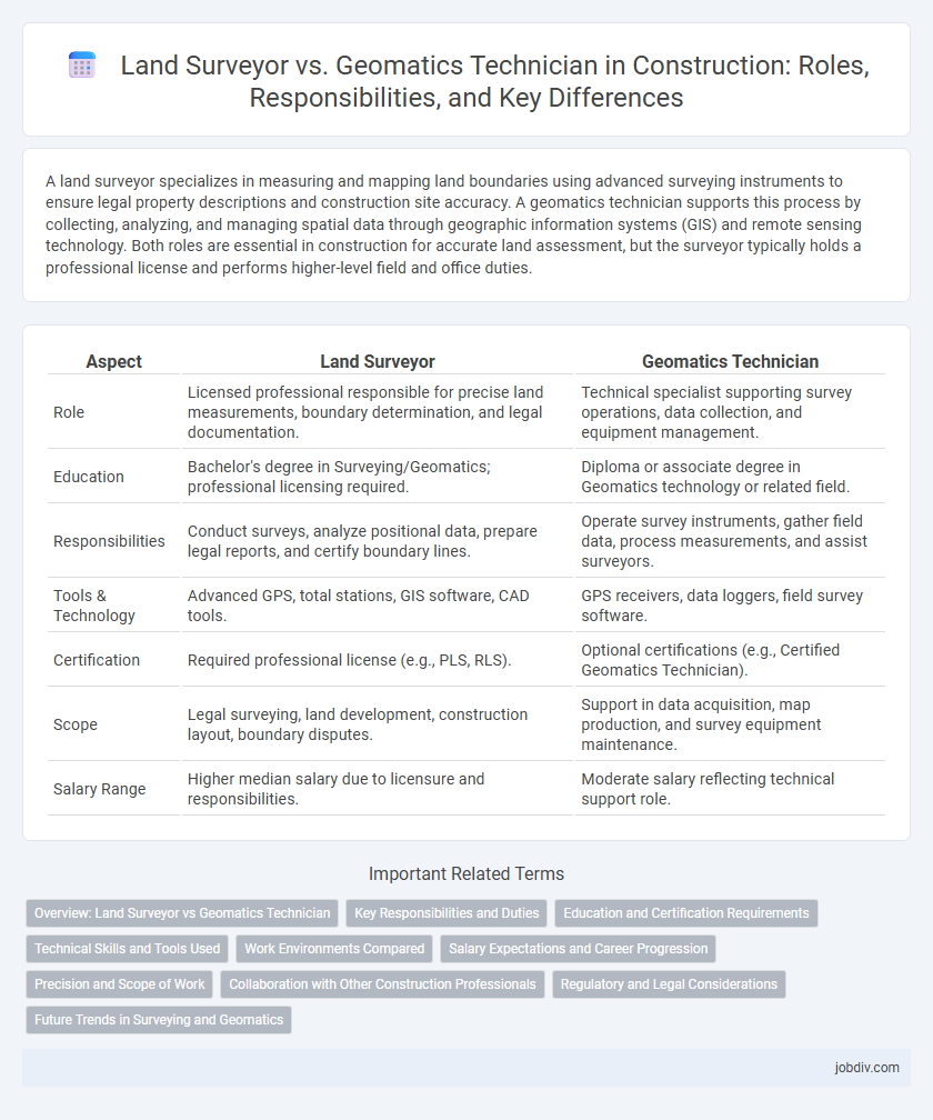
Table of Comparison
| Aspect | Land Surveyor | Geomatics Technician |
|---|---|---|
| Role | Licensed professional responsible for precise land measurements, boundary determination, and legal documentation. | Technical specialist supporting survey operations, data collection, and equipment management. |
| Education | Bachelor's degree in Surveying/Geomatics; professional licensing required. | Diploma or associate degree in Geomatics technology or related field. |
| Responsibilities | Conduct surveys, analyze positional data, prepare legal reports, and certify boundary lines. | Operate survey instruments, gather field data, process measurements, and assist surveyors. |
| Tools & Technology | Advanced GPS, total stations, GIS software, CAD tools. | GPS receivers, data loggers, field survey software. |
| Certification | Required professional license (e.g., PLS, RLS). | Optional certifications (e.g., Certified Geomatics Technician). |
| Scope | Legal surveying, land development, construction layout, boundary disputes. | Support in data acquisition, map production, and survey equipment maintenance. |
| Salary Range | Higher median salary due to licensure and responsibilities. | Moderate salary reflecting technical support role. |
Overview: Land Surveyor vs Geomatics Technician
Land surveyors specialize in measuring and mapping land boundaries with high precision, ensuring legal property delineations and construction site planning align with regulatory standards. Geomatics technicians support this process by utilizing advanced technology such as GPS, GIS, and remote sensing to collect, analyze, and visualize spatial data for engineering and environmental projects. The collaboration between land surveyors and geomatics technicians is essential for accurate topographic mapping, infrastructure development, and land management in construction.
Key Responsibilities and Duties
Land Surveyors are responsible for measuring and mapping land boundaries, preparing legal descriptions, and ensuring compliance with regulations using advanced surveying instruments and GPS technology. Geomatics Technicians assist in collecting, analyzing, and interpreting geospatial data, operating equipment such as total stations and geographic information systems (GIS) software to support surveying and mapping projects. Both roles collaborate on site surveys, data accuracy, and creating detailed maps critical for construction planning and land development.
Education and Certification Requirements
Land surveyors typically require a bachelor's degree in surveying, geomatics, or civil engineering, along with state licensure obtained through passing the National Society of Professional Surveyors (NSPS) exam or equivalent. Geomatics technicians generally need an associate degree or diploma in geomatics technology or surveying and often earn certifications such as the Certified Survey Technician (CST) credential from the American Congress on Surveying and Mapping (ACSM). Both professions emphasize proficiency in geographic information systems (GIS), global positioning systems (GPS), and land measurement techniques, with licensure mandatory for surveyors to legally perform boundary surveys and certify maps.
Technical Skills and Tools Used
Land surveyors utilize advanced GPS technology, total stations, and GIS software to create precise land measurements and boundaries, requiring strong skills in spatial analysis and legal land documentation. Geomatics technicians specialize in data collection and processing using laser scanners, drones, and remote sensing equipment, excelling in geospatial data interpretation and digital mapping techniques. Both roles demand proficiency in CAD software and an understanding of surveying principles but differ in the application of technical tools and analytical focus within construction projects.
Work Environments Compared
Land surveyors primarily operate on construction sites, urban development areas, and legal land boundary locations, often facing varying weather conditions and complex terrains. Geomatics technicians tend to work in both field environments and office settings, utilizing advanced computer systems to process spatial data and support mapping projects. Both professions require collaboration with engineers and planners but differ as surveyors focus more on precise measurements, while technicians handle data analysis and technology integration.
Salary Expectations and Career Progression
Land surveyors typically earn higher salaries than geomatics technicians due to their advanced responsibilities in measuring land and legal boundary assessments, with median annual wages around $70,000 compared to $50,000 for geomatics technicians. Career progression for land surveyors often leads to senior project management or licensed surveyor roles, while geomatics technicians might advance to specialist roles in GIS or remote sensing technologies. Both careers benefit from certifications, but licensed surveyor status significantly boosts earning potential and leadership opportunities.
Precision and Scope of Work
Land surveyors deliver high-precision measurements critical for defining legal property boundaries and construction layouts, utilizing advanced equipment and geospatial data analysis. Geomatics technicians support these efforts by collecting, processing, and managing spatial data but typically operate under the direction of land surveyors or engineers, handling broader scopes like mapping and geographic information systems (GIS). The precision of land surveyors is paramount for legal accuracy, whereas geomatics technicians prioritize comprehensive spatial data management across various construction and infrastructure projects.
Collaboration with Other Construction Professionals
Land surveyors and geomatics technicians work closely with engineers, architects, and construction managers to ensure precise site measurements and data integration throughout the project lifecycle. Land surveyors provide accurate boundary definitions and topographical data critical for design and permitting, while geomatics technicians manage digital mapping and data analysis to support project planning and monitoring. This collaboration enhances spatial accuracy, reduces errors, and streamlines communication across construction teams for successful project delivery.
Regulatory and Legal Considerations
Land surveyors are licensed professionals authorized to perform boundary surveys, property staking, and legal land descriptions essential for regulatory compliance and dispute resolution. Geomatics technicians support surveyors by collecting and processing geospatial data but typically lack the licensing required to certify legal documents or perform formal boundary determinations. Regulatory frameworks mandate that only certified land surveyors can produce official survey plats and boundary certificates used in legal and construction permits.
Future Trends in Surveying and Geomatics
The future trends in surveying and geomatics emphasize the integration of advanced technologies such as drone surveying, LiDAR, and AI-powered data analysis, significantly enhancing accuracy and efficiency. Land surveyors increasingly adopt these innovations for precise boundary mapping and legal documentation, while geomatics technicians specialize in managing and interpreting complex geospatial data through GIS and remote sensing tools. This convergence drives a collaborative approach, optimizing project outcomes in construction site planning, infrastructure development, and environmental monitoring.
Land Surveyor vs Geomatics Technician Infographic