Utility surveyors specialize in accurately locating and documenting underground utilities to prevent damage during construction, using techniques such as ground-penetrating radar and GPS mapping. Utility mappers focus on creating detailed utility maps and 3D models that integrate data from multiple sources, providing comprehensive visualization for project planning and management. Both professionals play crucial roles in infrastructure projects by ensuring safe excavation and efficient utility management.
Table of Comparison
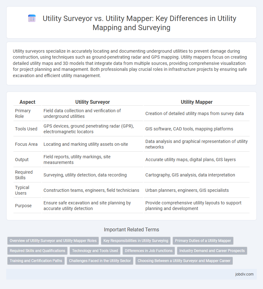
| Aspect | Utility Surveyor | Utility Mapper |
|---|---|---|
| Primary Role | Field data collection and verification of underground utilities | Creation of detailed utility maps from survey data |
| Tools Used | GPS devices, ground penetrating radar (GPR), electromagnetic locators | GIS software, CAD tools, mapping platforms |
| Focus Area | Locating and marking utility assets on-site | Data analysis and graphical representation of utility networks |
| Output | Field reports, utility markings, site measurements | Accurate utility maps, digital plans, GIS layers |
| Required Skills | Surveying, utility detection, data recording | Cartography, GIS analysis, data interpretation |
| Typical Users | Construction teams, engineers, field technicians | Urban planners, engineers, GIS specialists |
| Purpose | Ensure safe excavation and site planning by accurate utility detection | Provide comprehensive utility layouts to support planning and development |
Overview of Utility Surveyor and Utility Mapper Roles
Utility Surveyors specialize in accurately locating and documenting underground utilities through field surveys, using advanced equipment such as ground-penetrating radar and electromagnetic locators to ensure precise mapping data. Utility Mappers focus on creating detailed maps and digital representations of utility networks, integrating survey data into GIS platforms for effective visualization and management. Both roles collaborate to enhance infrastructure planning, reduce construction risks, and ensure compliance with safety regulations.
Key Responsibilities in Utility Surveying
Utility Surveyors primarily focus on identifying, locating, and documenting underground utility assets to ensure accurate mapping and safe construction planning. Their key responsibilities include conducting site assessments, verifying utility ownership, and liaising with utility companies to gather essential data. Utility Mappers specialize in creating precise digital maps of utility networks using advanced technologies such as GIS and ground penetrating radar, supporting infrastructure management and development projects.
Primary Duties of a Utility Mapper
A Utility Mapper specializes in accurately locating and mapping underground utilities using advanced technologies such as ground-penetrating radar (GPR), electromagnetic detection, and GPS systems. Their primary duties involve creating detailed utility maps to prevent damage during construction and maintenance activities, ensuring safety and regulatory compliance. They analyze subsurface conditions, interpret utility data, and provide precise spatial information to engineers, contractors, and project managers.
Required Skills and Qualifications
Utility surveyors require proficiency in land surveying techniques, knowledge of local utility regulations, and experience with geographic information systems (GIS) to accurately locate and document underground utilities. Utility mappers must excel in interpreting utility plans, using advanced mapping software, and applying remote sensing technologies such as ground-penetrating radar for precise underground infrastructure detection. Both roles demand strong analytical skills, attention to detail, and familiarity with safety standards in utility construction and maintenance.
Technology and Tools Used
Utility Surveyors primarily use GPS, total stations, and ground-penetrating radar (GPR) to accurately locate and document underground utilities with high precision. Utility Mappers employ advanced remote sensing technologies such as electromagnetic induction, LiDAR, and sonar to detect and visualize utility infrastructures in complex environments. Both professionals leverage Geographic Information Systems (GIS) software to integrate and analyze spatial data, enhancing the accuracy and efficiency of utility mapping and surveying projects.
Differences in Job Functions
Utility Surveyors specialize in locating and accurately mapping underground utilities through on-site inspections, using tools such as ground-penetrating radar and GPS technology. Utility Mappers primarily focus on creating detailed utility maps and integrating data into geographic information systems (GIS) to support infrastructure planning and maintenance. The key difference lies in Utility Surveyors conducting field data collection and validation, while Utility Mappers emphasize data analysis, visualization, and spatial data management.
Industry Demand and Career Prospects
Utility Surveyors possess expertise in identifying, locating, and mapping underground utilities, leveraging advanced technologies like GPS and ground-penetrating radar, which drives strong industry demand in construction and infrastructure projects. Utility Mappers specialize in creating detailed utility maps and integrating data into GIS platforms, a critical skill as urban development and smart city initiatives expand the need for precise utility data management. Career prospects for both roles are robust, with growing emphasis on utility mapping accuracy and regulatory compliance, ensuring continued job growth in engineering, surveying, and urban planning sectors.
Training and Certification Paths
Utility surveyors typically undergo formal education in surveying or civil engineering, followed by certification such as the Certified Utility Locator (CUL) or Professional Land Surveyor (PLS) credentials to ensure expertise in locating and mapping underground utilities. Utility mappers often receive specialized training in geographic information systems (GIS), remote sensing, or utility mapping technologies, with certifications like the Geographic Information Systems Professional (GISP) or utility mapping-specific courses to enhance technical skills in data collection and spatial analysis. Both roles require continuous professional development to stay compliant with industry standards and advances in utility detection and mapping technologies.
Challenges Faced in the Utility Sector
Utility surveyors face challenges related to accurately locating and documenting underground assets amid complex urban infrastructures and evolving regulatory requirements. Utility mappers struggle with interpreting diverse data sources and integrating advanced technologies like GIS and ground-penetrating radar to provide precise utility maps. Both roles must navigate safety risks, data inconsistencies, and the need for real-time updates to support efficient utility management and maintenance.
Choosing Between a Utility Surveyor and Mapper Career
Choosing a career between a utility surveyor and a utility mapper depends on your expertise and interests in infrastructure documentation. Utility surveyors specialize in precise field measurements and legal documentation of underground and overhead utilities, ensuring compliance and accuracy for construction projects. Utility mappers focus on creating detailed spatial representations using GIS technology to visualize, analyze, and manage utility networks for planning and maintenance.
Utility Surveyor vs Utility Mapper Infographic